A coalition of scientists and environmental advocacy groups has developed a camera-equipped drone they say could become a key conservation tool for monitoring
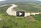
forest loss and endangered wildlife. The coalition — which includes The Orangutan Conservancy, the Denver Zoo, and two Swiss scientists — has already deployed a remote-control drone to map deforestation and count orangutans in the remote forests of North Sumatra in Indonesia, according to a report in Mongabay. The drone, which was developed by ecologist Lian Pin Koh at ETH Zürich, is able to travel a pre-programmed flight route and take aerial photos and video footage. During 30 flights so far, it has collected hundreds of photos and hours of video, including images of oil palm plantings along the edge of a river.
Conservationists Launch Drone To Monitor Forest Loss and Wildlife
More From E360
-
INTERVIEW
Marina Silva on Brazil’s Fight to Turn the Tide on Deforestation
-
Solutions
Solomon Islands Tribes Sell Carbon Credits, Not Their Trees
-
INTERVIEW
With Sea Turtles in Peril, a Call for New Strategies to Save Them
-
RIVERS
Jared Kushner Has Big Plans for Delta of Europe’s Last Wild River
-
Energy
A Nuclear Power Revival Is Sparking a Surge in Uranium Mining
-
OPINION
Despite Official Vote, the Evidence of the Anthropocene Is Clear
-
INTERVIEW
At 11,500 Feet, a ‘Climate Fast’ to Save the Melting Himalaya
-
Oceans
Octopuses Are Highly Intelligent. Should They Be Farmed for Food?
-
Climate
Nations Are Undercounting Emissions, Putting UN Goals at Risk
-
Solutions
As Carbon Air Capture Ramps Up, Major Hurdles Remain
-
ANALYSIS
How China Became the World’s Leader on Renewable Energy
-
Biodiversity
As Flooding Increases on the Mississippi, Forests Are Drowning