New NASA satellite images show that the surface of virtually the entire ice sheet covering Greenland experienced melting in mid-July, a phenomenon not
seen in three decades of satellite observations. Temperatures rose so high that ice on the Greenland’s highest peak, Summit Station, turned to slush, NASA said. Until the severe melting earlier this month, the greatest extent of surface melting observed by satellites over the past three decades covered about 55 percent of the ice sheet; on July 12, 97 percent of the ice sheet experienced surface melting. Ice cores from Greenland show that such melting events have occurred roughly every 150 years, but Greenland’s ice sheet has been experiencing rapid melting in the past decade and if another major melting event occurred within the next 10 years it could disrupt the stability of the ice sheet, said Thomas Mote, a climatologist at the University of Georgia. “When we see melt in places that we haven’t seen before, at least in a long period of time, it makes you sit up and ask what’s happening,” NASA scientist Waleed Abdalati told the BBC.
Click to enlarge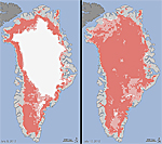
NASA
Extent of Greenland ice melt, July 8-12
Â
Â