Swiss researchers have released a series of high-resolution maps depicting the global distribution of permafrostand highlighting those regions where thawing permafrost as a result of global warming could
have the most profound effects. In a study published in The Cryosphere, glaciologist Stephan Gruber from the University of Zurich estimated that permafrost regions cover about 22 million square kilometers worldwide — or about one-sixth of Earth’s exposed land surface — including vast regions of Siberia, Central Asia, and the Himalayas and the Tibetan Plateau (shown above). Using high-resolution temperature and elevation data, he produced maps documenting the probability of permafrost existing. Thawing permafrost can cause building subsidence and collapse and can trigger the release of significant amounts of methane, a potent greenhouse gas. “As a result of climate change, areas with permafrost have a great potential for unpleasant surprises,” Gruber said.
Click to enlarge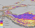
University of Zurich
Permafrost regions in the Himalayas