A historic flood has sent the highest water levels ever recorded through the Mississippi River south of St. Louis, toppling records
set during the devastating floods of 1993. The massive surge follows heavy rains that dropped up to 12 inches of water across the region during a three-day period in late December. A NASA satellite recently acquired this image of flooding along the Mississippi River from January 3rd, which shows floodwaters as blue and vegetation as green. The previous day, the waters caused the highest flood on record at Cape Girardeau, a Missouri town south of St. Louis. The flood water will continue to move southward, National Weather Service forecasters say, cresting in northwestern Tennessee today and in Memphis, Tennessee, by the end of the week. Some researchers point to modern river management strategies enacted by the U.S. Army Corps of Engineers, such as levees and dams that constrain the river, for exacerbating the effects of the heavy rainfall.
Enlarge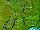
Satellite image of flooding along the Mississippi River