A pair of NASA satellite images comparing water flow along the Mississippi River this month with August 2011 illustrates the effects of a severe summer drought along the critical waterway. The recent photo, taken just south
of Memphis, Tennessee on Aug. 8, reveals extensive sandbars that are newly exposed or far larger than they were a year ago. Numerous stretches of the river have become significantly narrowed by decreased water flow. The drought, the worst in 56 years, has left the Mississippi River at its lowest levels since 1988, with some areas more than 12 feet lower than normal conditions at this time of year. Ninety-seven vessels were stranded by low waters near Greenville, Mississippi, where an 11-mile stretch of the river was closed for dredging. Near St. Louis, the U.S. Army Corps of Engineers has been forced to stop river traffic for up to 12 hours at a time in order to keep the shipping lane wide enough, according to Reuters.
Click to enlarge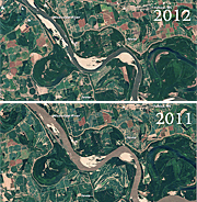
NASA
The Mississippi River, 2011-2012