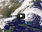
As the storm that was Hurricane Sandy weakened over Pennsylvania, NASA released a timelapse animation of the lifespan of the massive storm, tracking its path from the Caribbean, where it developed, to its violent landfall on the mid-Atlantic coast of the U.S. The collection of images, taken by the NASA GOES-13 satellite from Oct. 23 to Oct. 31, illustrates the storm gaining intensity as it traveled north, at times reaching nearly 1,000 miles in width. When the storm reached the mid-Atlantic on Oct. 29, it became wedged between a cold front over the Appalachian Mountains and a high-pressure air mass over maritime Canada, preventing it from moving north or east and instead driving it ashore. At that point Sandy became a Nor’easter, triggering historic storm surges in coastal areas of New York and New Jersey and blizzard conditions in the mountain regions. Meteorologists say the swath of high winds produced by Sandy while it was a hurricane covered nearly 2 million square miles.
Timelapse of Hurricane Sandy Shows Birth and Death of Historic Storm
More From E360
-
INTERVIEW
Marina Silva on Brazil’s Fight to Turn the Tide on Deforestation
-
Solutions
Solomon Islands Tribes Sell Carbon Credits, Not Their Trees
-
INTERVIEW
With Sea Turtles in Peril, a Call for New Strategies to Save Them
-
RIVERS
Jared Kushner Has Big Plans for Delta of Europe’s Last Wild River
-
Energy
A Nuclear Power Revival Is Sparking a Surge in Uranium Mining
-
OPINION
Despite Official Vote, the Evidence of the Anthropocene Is Clear
-
INTERVIEW
At 11,500 Feet, a ‘Climate Fast’ to Save the Melting Himalaya
-
Oceans
Octopuses Are Highly Intelligent. Should They Be Farmed for Food?
-
Climate
Nations Are Undercounting Emissions, Putting UN Goals at Risk
-
Solutions
As Carbon Air Capture Ramps Up, Major Hurdles Remain
-
ANALYSIS
How China Became the World’s Leader on Renewable Energy
-
Biodiversity
As Flooding Increases on the Mississippi, Forests Are Drowning
