A new online mapping tool could help governments and investors evaluate the geothermal energy potential for locations around
the globe through satellite measurements, lowering the risks and costs involved in developing this clean energy source, its creators say. The tool uses gravity measurements from European Space Agency (ESA) satellites to look for certain characteristics unique to geothermal reservoirs, including areas with thin crusts, subduction zones, and young magmatic activity. This helps determine which locations are most likely to possess geothermal energy potential, narrowing the search — and cost — for prospectors. The project, which is a partnership between the ESA and the International Renewable Energy Agency (IRENA), will “help make a strong business case for geothermal development where none existed before,” said a director at IRENA.
Enlarge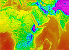
Geothermal mapping tool