A new map released by U.S. scientists illustrates a steep drop in groundwater levels across much of Texas and other southern states following record-breaking drought conditions. Using groundwater calculations based on satellite observations and other meteorological data, scientists at NASA’s Goddard Space Flight Center and the University of Nebraska have shown that ground moisture in some regions of the U.S. — including much of Texas — has dipped to levels significantly lower than the long-term average since 1948, when levels of soil moisture and groundwater were first recorded. In eastern Texas, for instance, the ground has been as dry as it currently is only 2 percent of the time over the last 63 years. According to scientists, groundwater supplies are “extremely depleted” across more than half of Texas and parts of New Mexico, Louisiana, Alabama, and Georgia.
Click to enlarge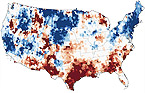
NASA
Groundwater levels in the U.S., November 2011