New maps of the seafloor created using satellite data reveal thousands of uncharted mountains and clues
about the formation of continents, researchers say. Among other findings, they identified a ridge in the Gulf of Mexico that had previously been associated with seafloor spreading, a major rift in the South Atlantic Ocean, and thousands of sea mountains — all of which had never before been documented. The maps are based on small ripples and dips in the surface of the ocean, which can be detected by satellites, the researchers explain in the journal Science. Using these ocean surface variations, the scientists were able to infer the shape and contours of the new seafloor features. Previously, the only way to create detailed maps was to collect depth soundings from ships sailing directly over the seafloor, so only about 20 percent of the ocean floor had been accurately mapped, researchers say.
Enlarge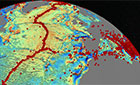
New detailed seafloor maps