Rapid agricultural expansion destroyed nearly two-thirds of the mangrove forestsin Myanmar’s Ayeyarwady Delta between 1978 and 2011, increasing the region’s vulnerability to cyclones and typhoons, according to a new study. Using remote sensing imagery
and field data, researchers from Myanmar and Singapore said that the dense mangrove cover in the Ayeyarwady Delta declined from 2,623 square kilometers to 1,000 square kilometers in that 33-year period. The main cause was agriculture expansion and the researchers said that if rates of destruction continue at their current pace the delta’s mangroves could be completely deforested by 2026. Reporting in the journal Global Environmental Change, the scientists said the loss of mangroves in the Ayeyarwady Delta could put the region at greater risk of major storms such as Cyclone Nargis, which killed 138,000 people in Myanmar in 2008. But the researchers said the destruction could be slowed if Myanmar creates coastal protected areas.
Click to Enlarge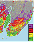
Webb et al., 2013
Mangrove forest loss