A new map released by NASA depicts the large scale of wildfires sweeping across the western U.S. and Mexico, where experts say exceptionally dry conditions have made many regions a tinderbox. The map, based on
satellite data collected by the agency’s Ozone Mapper Profile Suite, illustrates high atmospheric concentrations of aerosols (including smoke particles) from Mexico to Montana. Intense fires in Colorado, Utah, and Nevada are marked by dark brown and rust-red on the map, reflecting a high concentration of smoke and aerosols. High aerosol concentrations also are visible over parts of Texas and Mexico, probably as a result to a combination of dust and fires in dry regions. A fire official in Colorado, where ten separate fires are currently burning, said that a light winter snow pack, dry conditions, and the long-term effects of climate change combined to make the region especially susceptible to fires this year.
Click to enlarge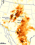
NASA
Smoke across U.S. West and Mexico
Â
Â