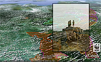
A new animation produced by the group WWF-Indonesia offers a tree-level tour of a biodiversity rich region of Sumatran rainforest targeted for destruction by logging companies. The animation, created using Google Earth, highlights proposed logging efforts in a region known as Bukit Tigapuluh, or “Thirty Hills,” a landscape that is home to endangered Sumatran tigers, elephants, rhinos, and orangutans, and represents one of the last large blocks of untouched forest in the area. While some parts of the region are protected as a national park, a large segment of lowland forest is located outside protected areas and is already concessioned for logging by major logging conglomerates. Google Earth has become an increasingly popular campaign tool for environmental organizations. Groups such as the Amazon Conservation Team and Amazon Watch have used it in efforts to halt illegal logging and the proposed construction of a dam on the Amazon River.
Google Earth Animation Highlights Region Targeted for Logging
More From E360
-
INTERVIEW
Marina Silva on Brazil’s Fight to Turn the Tide on Deforestation
-
Solutions
Solomon Islands Tribes Sell Carbon Credits, Not Their Trees
-
INTERVIEW
With Sea Turtles in Peril, a Call for New Strategies to Save Them
-
RIVERS
Jared Kushner Has Big Plans for Delta of Europe’s Last Wild River
-
Energy
A Nuclear Power Revival Is Sparking a Surge in Uranium Mining
-
OPINION
Despite Official Vote, the Evidence of the Anthropocene Is Clear
-
INTERVIEW
At 11,500 Feet, a ‘Climate Fast’ to Save the Melting Himalaya
-
Oceans
Octopuses Are Highly Intelligent. Should They Be Farmed for Food?
-
Climate
Nations Are Undercounting Emissions, Putting UN Goals at Risk
-
Solutions
As Carbon Air Capture Ramps Up, Major Hurdles Remain
-
ANALYSIS
How China Became the World’s Leader on Renewable Energy
-
Biodiversity
As Flooding Increases on the Mississippi, Forests Are Drowning