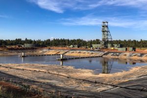
![Coal companies conducted widespread mountaintop removal mining [seen here in yellow and red] from 1985-2015 at the intersections of Perry, Knot, and Breathitt counties in Kentucky.](/assets/site/Mountaintopremoval1985-2015KY_web.jpg)
Coal companies conducted widespread mountaintop removal mining [seen here in yellow and red] from 1985-2015 at the intersections of Perry, Knot, and Breathitt counties in Kentucky. SkyTruth
From 1985 to 2015, coal companies blasted an average of 21,000 acres of Appalachian land every year in search of coal — an area about half the size of Washington, D.C., according to a new satellite mapping tool that allows users to track mountaintop removal over the last three decades in 74 key coal-mining counties.
Since the 1970s, scientists estimate that 1.5 million acres of mountainside in Appalachia have been removed for coal mining. “That is an area 18 percent larger than the state of Delaware,” Andrew Pericak, an environmental monitoring expert at Duke University, said in a statement. Pericak and colleagues at Duke worked with researchers at the nonprofit organizations SkyTruth and Appalachian Voices to create the new mapping tool. They published their findings this month in the journal PLOS One.
The scientists found that coal in the region is getting more difficult to extract. In the 1980s and 1990s, coal companies had to blast 100 square feet of land to get one ton of coal. By 2010, this had jumped to 160 square feet per ton, and by 2015, more than 300 square feet.
To create the mapping tool, which is free for anyone to use, the scientists analyzed 10,240 United States government satellite images taken in Kentucky, Tennessee, Virginia, and West Virginia dating back to 1985. They then measured over time the “greenness” of each pixel, representing 100- by 100–square-foot plots. Taking changes in seasonal vegetation into account, any pixel that was devoid of greenness and wasn’t part of a city, road, or body of water was labeled as an area where mining was likely happening.
“Any scientist interested in studying the impacts of mountaintop mining can now see exactly where mines are in the landscape and how long those impacts have been active,” said Emily Bernhardt, a Duke University researcher who is using the data to understand more precisely how mountaintop mining affects water quality.