The European Space Agency has begun launching a series of satellites designed to collect detailed environmental data around the globe — from radar-based, high-definition imagery to information about the
atmosphere’s chemical composition. The first satellite in the ESA’s Copernicus program, the Sentinel 1A, was launched last month and has already returned many striking images based on radar data, such as this view of Brussels, Belgium, in which the dense urban area contrasts with the city’s heavily vegetated surroundings. Once Sentinel satellite 1B is launched next year, the two will be able to map the entire globe in six days, giving researchers and conservationists a powerful way to monitor both short- and long-term changes in the environment. Four additional groups of satellites are set to launch this year. Those arrays will focus on high-resolution photo imagery, topography, surface temperatures, and atmospheric chemistry.
Click to Enlarge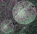
Land use near Brussels, Belgium.