Geophysicist Lori Dengler of Humboldt State University in California has traveled the world studying the impacts of tsunamis and working with governments to mitigate their wrath. Earlier this year, just weeks before the recent Japanese earthquake and tsunami, Dengler was in Tokyo, attending a meeting of Japanese port officials interested in better preparing for the tsunamis that will inevitably strike their earthquake-prone nation.
Even years of visiting regions struck by tsunamis, such as the massively destructive Indian Ocean tsunami of 2004, did not prepare Dengler for the images of entire Japanese towns being obliterated by a 30-foot wall of water. Not even Japan, with its unsurpassed preparedness, could escape the destruction of a 9.0 earthquake and tsunami that has taken the lives of 10,000 to 20,000 people.
In an interview with Yale Environment 360, Dengler describes the long history of Japanese tsunamis, including an 1896 tsunami that killed 22,000 people in the same region as the recent disaster. The prehistoric record, Dengler explains, contains evidence of even more powerful tsunamis in Japan and along the western coast of North America — warning signs that nations across the Pacific rim need to further bolster their preparations for tsunamis. Referring to the scale of the latest tsunami, Dengler said, “It’s very humbling, and I’m not going to predict what Mother Nature will do next. But let’s just say that she holds all the cards.”
Yale Environment 360: Given all of the attention that has rightly been paid to the unfolding nuclear crisis in Japan, it almost seems as if we’ve lost sight of what an extraordinary geological event this was. Could you put this sequence in historical perspective?
Lori Dengler: Certainly big earthquakes and great tsunamis are no strangers to Japan. Japan has a long and tragic history with both, and the location of this event was really no surprise at all. We call it the Sanriku Coast of northeastern Honshu, and a number of very tragic events have occurred in that area, including the Meiji-Sanriku tsunami of 1896, when an estimated 22,000 people died. The highest water heights in that event approached 90 feet, in Iwate Prefecture.
So none of us [earthquake experts] were surprised by the location. What was certainly surprising was the size of this earthquake. When you look at Japan’s historic record of tsunamis, they’ve been generated by earthquakes that are in the magnitude 8 to 8.5 range. This was very clearly the largest magnitude earthquake recorded since we’ve had modern seismographs since 1900. The giant Tohoku District earthquake in 869 may have been close to this in size. There are certainly some people saying that this event was much larger than what the Japanese had been planning for. A magnitude 9 earthquake is 30 times more energetic than a magnitude 8, and more important are the dimensions of the fault rupture.
A typical magnitude 8 might be on the order of a hundred miles long and 50 to 60 miles in width. This rupture was about 350 miles long and 150 to 175 miles in width. That is an enormous area to be deformed and a phenomenal volume of ocean of seawater that is displaced, and the largest surges fall right back on to the nearby coastline and the remaining surges head out across the Pacfic. It’s not that we haven’t had earthquakes that size before. We had an 8.8 in northern Chile only a little over a year ago and of course the great Indian Ocean tsunami in 2004 caused by the Andaman-Sumatra earthquake — that was a magnitude around 9.2. This earthquake is still not as big as the largest earthquake that we’ve ever recorded with modern instruments, a 9.5, and that occurred in 1960 when a very similar kind of fault ruptured much of the south-central Chilean subduction zone.
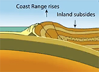
These great earthquakes do an incredible modification of the Earth’s surface. In the recent Japan earthquake, the plate that is subducting is the Pacific plate and it’s going under the North American plate. Most of the time those two are stuck together, but the Pacific plate is continuing to subduct all the time. It’s moving at about the rate that your fingernails grow. So that subducting plate is being basically pulled down by gravity. And as that plate gets pulled underneath it literally squeezes or compresses the plate on top just like a giant spring. That may keep going on for hundreds or even a thousand years. When the strength of that bond between the two plates is finally too great, we get this mega-thrust earthquake, this rupture that goes along the fault system. The overriding plate suddenly springs back. And it probably wasn’t just one single rupture. There were probably a number of secondary faults that may have also ruptured near that edge.
e360: Could you make an analogy that the plate kind of springs up, almost like a floorboard that was under pressure that pops up all of a sudden?
Dengler: Yes. It’s like a spring that’s been loaded. So imagine this board has been pulled down, pulled down, pulled down and then suddenly it’s released, and it’s going to pop up very quickly.
e360: Right. Let me ask you about earlier earthquakes and tsunamis in Japan.
Dengler: The worst was in 1923 and that was the great Tokyo earthquake that killed something like 140,000 people.
e360: That was a smaller magnitude?
Dengler: It was smaller in magnitude, but that earthquake was centered very close to Tokyo and it triggered an enormous fire and the fire probably contributed to more deaths than the earthquake. The earthquake occurred at a time when people were preparing dinner and at that time they used these open fire braziers. Most of the homes were wood construction and it very, very quickly became an inferno. So that was without question the worst earthquake disaster. It did produce a tsunami, but not a great tsunami. Each one of these events has their distinctive set of parameters, and in one it may be ground-shaking damage, and in another it may be fire, and another it may be an enormous landslide or it could be a tsunami, or a combination of those things.
Japan has had numerous earthquakes as large as magnitude 8.5, and that may have been kind of their planning event. But it really points out the problem of dealing only with the historic record. Japan has records that go back a thousand years or longer — a much longer record than we have in the United States, where we really only have written records on the West Coast going back about 150 years, and we’ve only had actual seismic instruments going back about a hundred years.
“There is evidence that what has happened in the last thousand years is not necessarily the worst-case event.”
So in order to get a sense of the long term hazard, you need to go into what we call paleoseismology, paleoseismic techniques, which use the geologic record of past events to interpret the full scale of what you might be dealing with. And that’s certainly how we know the most about the hazard in Cascadia [U.S. Pacfici Northwest]. It comes primarily from the paleotsunami and paleoseismic studies that have been done in Northern California, Oregon, Washington, and British Columbia. Some of those studies have certainly been done in Japan as well, and several years ago Japanese researchers published a paper that suggested the past tsunamis were much, much larger than any that had been observed in historic times. The sand sheets particularly in some areas of Hokkaido and northern Honshu extended much, much further inland than the historic record suggested. And there certainly has been some discussion that earthquakes as large as low- to mid- magnitude 9 were possible in that area. I don’t know if that information had been incorporated into any of the planning for this event. But there was certainly some evidence that suggested that what had happened in the last thousand or so years was not necessarily the worst-case event.
e360: The paleo record shows sand sheets that come in from the sea and spread over the land?
Dengler: Exactly. And the problem with that evidence is that, first of all, it’s ephemeral — it will tend to be eroded. If you imagine the Pacific Northwest, we have a lot of rains. We have a lot of floods. So preserving it is difficult. And interpreting it can be difficult as well, and so there are a number of people who have become paleotsunami experts and by analyzing not only the sand, but looking at the micro fossils in it, you can look at the diatoms and forams and interpret them as coming from the ocean.
e360: In the historical record, you’ve got the Meiji-Sanriku tsunami and earthquake of 1896?
Dengler: Yes. So this was in the time of the Meiji emperors, so that’s how we often describe it.
e360: It originated in roughly the same area as the recent tsunami?
Dengler: Roughly the same area. That earthquake was quite different from this earthquake. It was what we call a tsunami earthquake. We use the term tsunami earthquake when the tsunami is much bigger than you would expect for either the size of the earthquake or the strength of the ground shaking. So in that particular case people didn’t feel the earthquake very strongly. It was weak shaking that lasted for a long time, but it didn’t knock things down. You had this earthquake, which didn’t feel very strong, and people didn’t tend to pay a lot of attention to it and unfortunately the tsunami was very large. In Japan there is an oral history that says that if you feel the earthquake you go to high ground. And when you have these tsunami earthquakes you just don’t tend to be as alarmed by the shaking. So one of the things that I always tell people is pay attention to how long the shaking lasts. It may not feel all that strong, but if you count ground shaking that lasts 30 seconds or longer, then that’s your warning and you really do need to evacuate.
e360: And in the 1896 tsunami, virtually all the deaths were from the tsunami?
Dengler: There was no damage at all from the earthquake. It was entirely the tsunami.
e360: Were the same coastal regions that were hit two weeks ago also hit in the 1896 tsunami?
Dengler: There was a lot of overlap. And the 869 Tohoku tsunami affected many of the same areas, as well.
e360: And was there an estimate of deaths back then?
Dengler: The estimate was over 1,000 deaths in 869 and that flooded a castle in Sendai, so really the same areas flooded… One of the things that is going to be emerging from this recent tsunami is the focus has been on the failures, because clearly when you have 10,000 or maybe even 20,000 deaths, it’s a catastrophe. But there were hundreds of thousands of people exposed and there are certainly successes as well. And we just haven’t been hearing about them yet.
e360: Successes in terms of warnings…
Dengler: Of people successfully evacuating and surviving. I think we are going to find out that many more people lived than died that were in the tsunami area, and that’s quite different than what happened in the 2004 Indian Ocean tsunami, where virtually everybody that was in the inundation zone died because they were unaware of the natural warning signs of a tsunami, and at places further away from the source, in Thailand and in Sri Lanka, there was no kind of warning system. So I’m sure that there will be many successes that will come out of this and that’s important to remember.
e360: In North America, is there a similar plate structure off of Cascadia and Northern California so that you could have an earthquake and tsunami of similar intensity in the Pacific Northwest?
“At the top of the list of things we need to work on is public awareness and public education.”
Dengler: Yes. And in fact we know perhaps the most about the potential for such an earthquake and tsunami from the written records in Japan. On January 26, 1700 we had a very similar rupture in the Pacific Northwest. It probably extended from south of Eureka, in northern California, up into about the middle of Vancouver Island, Canada. And given that length and given what we know about the Cascadia subduction zone, it was probably about a magnitude 9. The earthquake rupture caused the same kind of phenomenon, with permanent deformation of the coastlines, killing many forests of western red cedar, redwood trees, pines, and spruce. The western red cedar, though, is a particularly important tree because it doesn’t rot very quickly and there are still today stands of ghost forests, these western red cedar that died in that event. Because there are still living trees from the same grove that were a little higher up, it is possible using the science of dentrochronology [reading tree rings] to actually create the time history of those trees and when they died. If you’re really careful and work on the roots, you can actually figure out the death date of those trees. That was done in southern Washington State and they found seven trees they could actually get a good death date on. And of those seven trees, six of them put on 1699 growth rings and did not put on 1700 growth rings. And as I said from the Japan written records, the tsunami came on January 26, 1700.
In Japan in 1700, we’re in the height of the Togakawa Shogunate, a very stable period in Japan, which means the bureaucrats are writing down records. Lots of taxes were being paid to the Shogun, and the taxes are basically paid as rice, and the rice gets stored in warehouses close to rivers and close to ports. And so we’ve got these reports of the tsunami coming in and it wiped out so many bags of rice and it came up this high. We can actually get a pretty good estimate of how high the water came in 1700 and when it arrived. And, from that, you can actually do numerical modeling that also says you basically need a magnitude 9 earthquake in order to produce that size of a tsunami. Both sides of the ocean, we give and take to each other.
e360: And how far off the Cascadia Coast was this fault line from 1700?
Dengler: It was the edge or the Cascadia subduction zone, which is defined by the continental shelf. So you can see that it is very close to the northern California coast. It is only about 50 miles off the coast. By the time you get off the Washington coast, it’s over a hundred miles off the coast. So we would expect when that fault system ruptures, the first surges are going to arrive on the northern California coast in as little as 10 minutes after the earthquake rupture. By the time you get up to the Washington coast you are probably dealing with closer to 20 minutes, unless the ground shaking also triggers a submarine landslide much closer to the coast, in which case a secondary tsunami could arrive even more quickly.
e360: So if you had a similar event to the 1700 tsunami off of Eureka and the Cascadia Coast, you could be looking at death and destruction on a scale of what just occurred in Japan?
Dengler: There are of course lots of uncertainties and the actual character of the rupture and the frequency of ground shaking is a huge unknown. We don’t have the exposure in terms of population [right on the coast] that that part of Japan had. We don’t have a Sendai that has hundreds of thousands of people potentially exposed. We do have lots of small communities that on a lovely summer day can have tens of thousands of people on the beach. So, you know, 4th of July, if it’s not foggy on the Oregon and Washington coast, you can have certainly many people exposed. And it’s something that we’re actively working on. We have tsunami hazard maps. We have hazard zone signs. Most of our coast is actually at fairly high elevations so it turns out most of the places where people live are actually not at great risk.
e360: What about San Francisco?
Dengler: Well San Francisco is probably not at great risk of a tsunami. Hawaii is going to get more damage from [a Cascadia] tsunami than San Francisco will. Alaska will get damage from our tsunami and Japan will get damage from our tsunami. So this event certainly has the capacity to cause significant problems throughout the Pacific basin. San Francisco is going to escape the worst of it because it’s on the good end of the rupture.
e360: How well would you say the U.S. and Canada are prepared for a big tsunami that would strike Hawaii and the West Coast?
Dengler: I’m sure there are going to be many hearings in the coming months that will be addressing this topic. Actually a number of [Congressional] hearings were held back in 1993 and 1994 after we had a 7.2 earthquake here on the North Coast on that same subduction zone fault system, but it was just the southern-most corner of it. But that earthquake was enough to really get people’s attention. As a result, the U.S. launched the National Tsunami Hazard Mitigation Program in 1996, funded solely by earmarks, until the 2004 Indian Ocean tsunami, when suddenly the funding jumped way up. The National Academy of Sciences and the National Research Council just finished a two-year study of the U.S. tsunami program that looked very, very carefully at all aspects of U.S. tsunami preparedness. It has certainly improved significantly from where it was a decade ago, but there are a number of areas that we need to continue to work on.
I would say top on that list is public awareness and public education. There is no question when you are dealing in the near-source region of a great earthquake everybody needs to understand that they can’t wait for an official warning. They can’t get in their car and drive. They need to be able to self-evacuate immediately. And we have a number of areas where there’s no high ground. An example is the Long Beach Peninsula in Washington State, where you have this big long sand pit with no high ground. We need to really be looking at issues of creating high ground, of vertical evacuation. It is going to be very interesting to see how Japanese vertical evacuation sites fared. I’ve heard some stories of the water being higher and completely overtopping some of them. But it’s too early right now to know. But if a Cascadia earthquake and tsunami were to happen this afternoon, we would certainly have major damage and we would lose lives due to the tsunami. I would like to think we would lose far fewer today than if it happened 20 years ago. So this is a work in progress, and we have a lot still to do.
e360: I think what’s been so stunning to everyone was that here’s this incredibly developed country [Japan] totally aware of the dangers it faces, and it still got absolutely creamed. It’s shocking.
Dengler: Absolutely. It’s extremely humbling and I’m not going to predict what Mother Nature will do next. But let’s just say she holds all the cards and is the last at bat.