I’m making a film in the Chesapeake Bay landscapes of my boyhood, posing for a close-up with ball and glove where 60 years ago I shagged flies out front of my Dad’s fishing cabin. The camera backs away and I’m ass-deep in salt water — centerfield, this used to be. The tall piney woods around the long-gone cabin, thick enough I worried then about getting lost, are skeletal now, falling into the water.
Cinematographer Dave Harp and I are longtime collaborators on Chesapeake projects and knew what we’d find when we began working on this film. The great estuary’s 11,000 miles of tidal shoreline have been eroding for centuries as wind and wave and ice take their toll. But now there’s a new ballgame. Emerging climate science has documented an ominous acceleration of the sea level rise that gradually formed the Chesapeake over thousands of years. The latest projections for the Chesapeake region are two feet or more of sea level rise by mid-century, and as much as six feet by century’s end. That’s a troubling combination of higher water and sinking land around the bay.
Dave and I have focused our cameras on my old stomping grounds, Dorchester County on Maryland’s Eastern Shore, a place where the future is well underway. “Water moves us” is the county’s tourism slogan, both apt and ironic. It’s been called “Maryland’s Everglades” — a wonderland of water and wetlands, tidal creeks and wooded swamps and islands, nurturing an abundance of seafood and wildlife, and home to historic fishing communities and the internationally-known Blackwater National Wildlife Refuge. With its hundreds of thousands of acres of land, Dorchester ranks fourth largest among Maryland’s 23 counties; but it will shrink to 14th by 2100 as nearly half the county turns to open water.
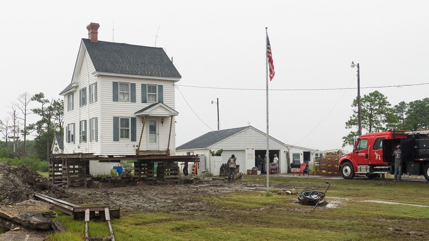
Mike Draper raised his house in southern Dorchester County seven feet to protect it from rising waters. Photo by Dave Harp
To most people, the word “tide” has only vague import — high and low, flooding and ebbing. But “tide” in Dorchester is rich with meaning: school bus schedules and shopping trips revolve around it; emergency responders reposition ambulances; and property owners truck in soil on which to park their cars, grow vegetable gardens, and install septic tanks.
In the southern portions of the county you can easier come by a bushel of crabs than a wheelbarrow load of dirt, observed Mike Draper, a recent homebuyer near the tiny settlement of Crocheron. We filmed as he jacked his house 7 feet in the air and built a low dike around the yard, while his son, Dan, prepared to fish tasty blue crabs from the tidal ditch along their road frontage.
But while you can raise a house if you’ve got the money (it cost Draper about $38,000 including the new foundation), you can’t raise the long, lonely marsh roadways serving residents throughout the lower-lying half of Dorchester. At least you can’t raise them easily. Dorchester has roads where the pavement is up to 5 feet thick—layer after layer applied, a couple inches at a time, as the road slowly sinks.
Even that may not be enough, says Ricky Travers, president of the Dorchester County Council. “I hope and pray in my time I don’t have to tell people they have to abandon their hard-earned property values, their communities, their heritage… because of rising water,” he says.
Dave and I, along with filmmaker Sandy Cannon Brown, began this film to educate people to the threats of climate change; but it became an education to us in how science might better communicate such complex information to local citizens.
We knew going in that phrases like global warming and sea level rise would never pass the lips of most of our interviewees. A woman whose family took my late wife and I fishing at 4 a.m. on our first date (she married me anyway), stubbornly refused to go on camera. Eventually she said what was on her mind: It would be too easy for us to “put me between two PhD’s and make me look like a fool.” Besides, “I just hate how the media puts fear in our hearts, talking about the land sinking and humans changing the climate.”
We talked some more, and she gave us an interview about how forests that once blocked her view of her church were gone now, about how the tide seemed to come over the land so much more frequently.
Many others just did not want to get into the notions of the seas rising; but yes, erosion did seem to have gotten worse than ever, some said. Many are watermen, the Chesapeake term for commercial fisherman. They believe what they see, focus on where to fish tomorrow, not on the century ahead.
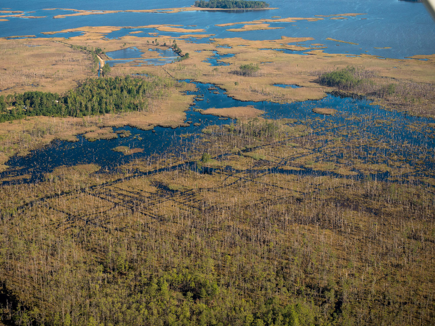
Saltwater intrusion has killed wide swaths of forest in Blackwater National Wildlife Refuge in Dorchester County. Photo by Dave Harp
“They’re not wrong about erosion. It’s happening very quickly, and it is very noticeable,” said Mike Scott, a geographer at Salisbury University, one county over from Dorchester. “Sea level rise at this point, unlike erosion, is happening very slowly — slight enough up to now that it’s actually very difficult to measure unless you’re taking very precise measurements.”
But the two processes are not separate, Scott explains. Rising seas make erosion worse, and the former is accelerating dramatically. According to Scott, the key is to acknowledge the threat and implement public policies that lead to an orderly retreat. “As we lose marshes, we’re going to need spaces on the landward edge for them to move into — we’re going to need to buy the development rights to such places from the people who own them now.” In places like Dorchester, he says, “if we can get hold of this in the next five to seven years, we have time to fix it that way. If we wait, then we will be in crisis mode.”
The county recently revised its building codes to require higher elevations for new building in flood-prone areas. It’s just a start.
The biggest challenge, says Anna Sierra, Dorchester’s emergency services director, is that “people are so tied to their culture and history here — incredibly proud of it, and they should be. Dorchester is a story of survival and adaptability to storms and flooding since the 1600s.
“It’s very challenging to recognize… long-term, it may all be inundated.”
— Tom Horton
About the Filmmakers:
Tom Horton has covered the environment for newspapers and magazines since 1972 and has authored several books on Chesapeake Bay. He currently writes for the monthly Bay Journal and teaches at Salisbury University in Maryland.
Sandy Cannon-Brown, founder and president of VideoTakes, Inc., is an award-winning environmental filmmaker and teacher. She was an associate director for American University’s Center for Environmental Filmmaking. She lives in St. Michaels, Maryland and focuses her independent films on issues affecting the Chesapeake Bay.
A lifelong Marylander, Dave Harp operates a corporate and editorial photography business in Cambridge, Maryland. He served as the staff photographer for the Hagerstown Morning Herald and was the photographer for The Baltimore Sun Magazine for nearly a decade.