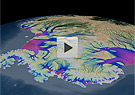
Scientists at the University of California, Irvine, have for the first time fully mapped the movement of Antarctica’s vast ice sheets and glaciers, which comprise 90 percent of the ice on Earth. Using data gathered by satellites from Europe, Canada, and Japan, the researchers have assembled a color animation depicting how the glaciers flow from the vast polar plateau to the Southern Ocean, with some ice sheets moving up to 800 feet a year. Lead researcher Eric Rignot said that the study showed conclusively that the rivers of ice move by slipping along their beds. “This is like seeing a map of all the ocean’s currents for the first time,” said Rignot. He and other scientists said that the glacial mapping project will be vital to understanding how Antarctica’s ice sheets and glaciers will react to warming temperatures, which will help scientists forecast future sea level rise. If glaciers and ice sheets melt more rapidly along Antarctica’s coasts because of rising ocean and air temperatures, that loss is likely to accelerate the flow of ice from Antarctica’s interior to the sea along the routes mapped by Rignot and his colleagues.
Antarctic Ice Movement Is Fully Mapped for the First Time
More From E360
-
Climate
How Climate Risks Are Putting Home Insurance Out of Reach
-
INTERVIEW
Inside the Plastics Industry Playbook: Delay, Deny, and Distract
-
Biodiversity
Freeing Captive Bears from Armenia’s Backyards and Basements
-
Food & Agriculture
In Indonesia’s Rainforest, a Mega-Farm Project Is Plowing Ahead
-
FILM CONTEST WINNER
In the Yucatan, the High Cost of a Boom in Factory Hog Farms
-
INTERVIEW
In the Transition to Renewable Energy, China Is at a Crossroads
-
E360 Film Contest
In India, a Young Poacher Evolves into a Committed Conservationist
-
E360 Film Contest
The Amazon Rainforest Approaches a Point of No Return
-
Biodiversity
Shrinking Cod: How Humans Are Impacting the Evolution of Species
-
Cities
‘Sponge City’: Copenhagen Adapts to a Wetter Future
-
INTERVIEW
On Controlling Fire, New Lessons from a Deep Indigenous Past
-
Solutions
Paying the People: Liberia’s Novel Plan to Save Its Forests