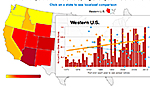
An interactive tool produced by the group Climate Central illustrates how rising temperatures and reduced snowpack in the western U.S. have corresponded with an increase in wildfiresin recent decades. Based on
federal wildfire data from 1970 to 2012, the graphic shows how large fires in some western states — including Arizona, Colorado, and Idaho — have doubled or even tripled in four decades, a period when the average spring and summer temperatures in 11 states increased by more than 1.5 degrees F. According to the Climate Central analysis, Arizona has experienced the highest average increase in spring temperatures, about 1 degree F, which has likely been a key factor in the steep increase in fires covering more than 1,000 acres. Another key factor has been the decrease in mountain snowpack. During several seasons, unusually low amounts of spring snow caused extended droughts that helped drive more big fires.
Map Shows Possible Link Between Warmer Springs and Large Fires
More From E360
-
Oceans
Dire Straits: Can a Fishing Ban Save the Elusive European Eel?
-
Climate
Scientists Are Trying to Coax the Ocean to Absorb More CO2
-
INTERVIEW
Marina Silva on Brazil’s Fight to Turn the Tide on Deforestation
-
Solutions
Solomon Islands Tribes Sell Carbon Credits, Not Their Trees
-
INTERVIEW
With Sea Turtles in Peril, a Call for New Strategies to Save Them
-
RIVERS
Jared Kushner Has Big Plans for Delta of Europe’s Last Wild River
-
Energy
A Nuclear Power Revival Is Sparking a Surge in Uranium Mining
-
OPINION
Despite Official Vote, the Evidence of the Anthropocene Is Clear
-
INTERVIEW
At 11,500 Feet, a ‘Climate Fast’ to Save the Melting Himalaya
-
Oceans
Octopuses Are Highly Intelligent. Should They Be Farmed for Food?
-
Climate
Nations Are Undercounting Emissions, Putting UN Goals at Risk
-
Solutions
As Carbon Air Capture Ramps Up, Major Hurdles Remain