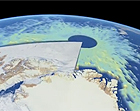
The European Space Agency’s (ESA) CryoSat satellite is now providing highly accurate data on the thickness and volume of Arctic Ocean ice. Using a high-resolution
synthetic aperture radar that sends down pulses of microwave energy, the satellite can measure the difference between the top of the ice and water in the cracks, or leads, that separate the floes. By measuring the height of the ice above water, which usually represents only one-eighth of total ice thickness, the satellite can provide data on ice thickness to within 10 to 20 centimeters, or 4 to 8 inches. The CryoSat satellite was launched in 2010, and since then scientists have been validating the measurements against other data from plane-based instruments and direct, on-ice measurements. “We now have a very powerful tool to monitor the changes taking place at the poles,” said Volker Liebig, the ESA’s director of Earth Observation.
European Satellite Provides Precise Data On Arctic Sea Ice Thickness
More From E360
-
OPINION
Trump’s Logging Push Thrusts a Dagger at the Heart of Wilderness
-
INTERVIEW
Pakistan’s Solar Revolution Is Bringing Power to the People
-
Food & Agriculture
In Uganda, Deadly Landslides Force an Agricultural Reckoning
-
Energy
Why U.S. Geothermal May Advance, Despite Political Headwinds
-
Food & Agriculture
In War Zones, a Race to Save Key Seeds Needed to Feed the World
-
Climate
Lightning Strikes the Arctic: What Will It Mean for the Far North?
-
RIVERS
A Win for Farmers and Tribes Brings New Hope to the Klamath
-
Solutions
Deconstructing Buildings: The Quest for New Life for Old Wood
-
NATURAL DEFENSES
How Restored Wetlands Can Protect Europe from Russian Invasion
-
Solutions
Birds vs. Wind Turbines: New Research Aims to Prevent Deaths
-
Biodiversity
Cambodian Forest Defenders at Risk for Exposing Illegal Logging
-
OPINION
The ‘Green’ Aviation Fuel That Would Increase Carbon Emissions