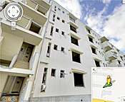
As part of an ongoing project to digitally archive the aftermath of the 2011 tsunami in northeastern Japan, Google has published several new panoramic images that provide a sobering glimpse of the widespread
devastation in communities across the region. The images, taken with the company’s Street View technology in four cities in the TÅhoku region, allows users to take a virtual tour of seriously damaged buildings before they are demolished. One panoramic view of a public housing project illustrates the height of the tsunami wave, which ruined everything up to the fourth floor of the building. Another image, of the condemned Ukedo Elementary School, shows the collapsed auditorium floor beneath the banner of a graduation ceremony that was never held. The images were added to Google’s “Memories for the Future” website, which is chronicling the affected areas from before and after the tsunami.
Google Images Document Devastation of 2011 Tsunami in Japan
More From E360
-
Oceans
Dire Straits: Can a Fishing Ban Save the Elusive European Eel?
-
Climate
Scientists Are Trying to Coax the Ocean to Absorb More CO2
-
INTERVIEW
Marina Silva on Brazil’s Fight to Turn the Tide on Deforestation
-
Solutions
Solomon Islands Tribes Sell Carbon Credits, Not Their Trees
-
INTERVIEW
With Sea Turtles in Peril, a Call for New Strategies to Save Them
-
RIVERS
Jared Kushner Has Big Plans for Delta of Europe’s Last Wild River
-
Energy
A Nuclear Power Revival Is Sparking a Surge in Uranium Mining
-
OPINION
Despite Official Vote, the Evidence of the Anthropocene Is Clear
-
INTERVIEW
At 11,500 Feet, a ‘Climate Fast’ to Save the Melting Himalaya
-
Oceans
Octopuses Are Highly Intelligent. Should They Be Farmed for Food?
-
Climate
Nations Are Undercounting Emissions, Putting UN Goals at Risk
-
Solutions
As Carbon Air Capture Ramps Up, Major Hurdles Remain