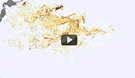
A new animation developed by researchers at the University of Hawaii’s International Pacific Research Center illustrates the likely path of the spreading field of debris caused by retreating waves from last year’s gigantic tsunami in Japan. The model —
based on satellite data and a network of scientific buoys showing sea surface height, ocean surface winds, and ocean currents — shows that debris swept into the Pacific by the event now likely stretches across an area covering 5,000 kilometers by 2,000 kilometers. Much of the debris was initially pulled by the strong Kuroshio Current, which travels past eastern Japan before shifting east and then into the North Pacific Current. The Japanese government estimates about 5 million tons of debris was pulled into the ocean; about 70 percent sank to the seafloor, with about 1.5 million tons still floating.
Model Shows Debris Field In Pacific From Japanese Tsunami
More From E360
-
Oceans
Dire Straits: Can a Fishing Ban Save the Elusive European Eel?
-
Climate
Scientists Are Trying to Coax the Ocean to Absorb More CO2
-
INTERVIEW
Marina Silva on Brazil’s Fight to Turn the Tide on Deforestation
-
Solutions
Solomon Islands Tribes Sell Carbon Credits, Not Their Trees
-
INTERVIEW
With Sea Turtles in Peril, a Call for New Strategies to Save Them
-
RIVERS
Jared Kushner Has Big Plans for Delta of Europe’s Last Wild River
-
Energy
A Nuclear Power Revival Is Sparking a Surge in Uranium Mining
-
OPINION
Despite Official Vote, the Evidence of the Anthropocene Is Clear
-
INTERVIEW
At 11,500 Feet, a ‘Climate Fast’ to Save the Melting Himalaya
-
Oceans
Octopuses Are Highly Intelligent. Should They Be Farmed for Food?
-
Climate
Nations Are Undercounting Emissions, Putting UN Goals at Risk
-
Solutions
As Carbon Air Capture Ramps Up, Major Hurdles Remain