British scientists have unveiled the most detailed topographical map available yet of Antarctica, a vast dataset that provides a penetrating 3-D view of the
frozen continent down to the bedrock level and could offer insights into how it will respond to climate change. Based on millions of measurements collected over decades, the British Antarctic Survey’s Bedmap2 project illustrates the continent with a level of clarity not previously available, including a vivid look at the mountain landscapes buried in ice and valleys that run deeper than had been known. The scientists say better understanding the landscape will help them predict the behavior of Antarctica’s ice sheet in future decades and the extent to which melting could increase sea levels. The map was based on data collected by satellites, land-based surveys, and ice-penetrating measurements of the subglacial bedrock.
Click to enlarge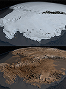
NASA Goddard Space Flight Center
Antarctica’s subglacial terrain