New, highly detailed maps of Peru’s vegetation show that three-quarters of the country’s forests — a biomass
stock that sequesters more carbon than the combined annual CO2 emissions of the U.S. and China — lie outside of protected areas and are vulnerable to deforestation, according to an analysis by researchers in the U.S. and Peru. The maps, which should prove helpful to scientists, conservationists, and policymakers working to protect the forests, offer the most detailed view to date of the different types of vegetative cover and above-ground carbon stocks across Peru, with resolution at the one-hectare scale. The analysis found that the lowlands of southern Peru, which contain extensive bamboo cover, harbor significantly less carbon than other rainforest areas, and forests in active floodplains appear to store half as much carbon as other forests.
Click to Enlarge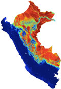
Carbon stocks across Peru