NASA researchers have developed a computer program that will use satellite data, information from wireless sensors in fields, and weather observations to help farmers more efficiently irrigate their fields. Irrigation accounts for nearly 70 percent of water use in the U.S., and NASA scientists say that their high-tech approach could improve irrigation efficiency by 20 to 25 percent. 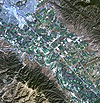 NASA is doing a test project with farmers and vineyard managers in California’s San Joaquin Valley, one of the most intensively farmed regions in the U.S. The project will combine temperature and moisture data from soil sensors with satellite data on crop growth to estimate irrigation needs of individual farms and then distribute that information in near real-time to farmers via computers or hand-held devices. Using that information, farmers can precisely determine how much water to release into their fields and vineyards, enabling them to use less water to produce the same yield.
NASA
Satellite view of Salinas, Calif.