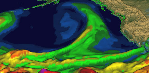
Like a pipeline in the sky, the plume of sodden tropical air advanced mile-high above the Pacific Ocean, heading toward the California coast. This “atmospheric river” — a long, narrow band of concentrated water vapor — carried the moisture equivalent of about 15 Mississippi Rivers. When it made landfall, it dumped a massive amount of rain on the densely populated stretch of California from San Francisco to Los Angeles, unleashing floodwaters, causing landslides, and cutting off power to hundreds of thousands of homes and businesses.
Atmospheric rivers fuel some of western North America’s most intense and destructive winter storms, and this one, slamming California last December, was a big one. But despite nearly a foot of rain in some places, damage was considerably less than it could have been, thanks to forecasts that pinpointed the storm’s course a week before it struck, giving communities time to prepare.
“I think that [forecast] was a home run,” said Mike Dettinger — a research hydrologist with the U.S. Geological Survey (USGS) and Scripps Institution of Oceanography in La Jolla, California — who studies atmospheric rivers. “That is how we feel the forecasts ought to work for us now.”
Early warnings for extreme weather like atmospheric rivers will be increasingly crucial in coming years as global warming keeps temperatures on the rise. A hotter planet will pump more energy into the atmosphere, setting off more extreme heat waves, lengthy droughts, intense storms, and other “high impact” events that can cause major property damage, economic havoc, widespread injury, and death. More frequent weather extremes could also trigger disease outbreaks, jeopardize food security and water availability, and even lead to political instability and civil unrest.
Advanced forecasting can help avert disasters, say scientists, who are harnessing unprecedented computing power, enhancing mathematical models, and devising new observation methods to provide better and longer-term forecasts for the stormier times ahead.
Tiny errors at the beginning of a forecast can lead to wide misses by the end.
“Improving our forecast capabilities is incredibly important,” said Paul Higgins, a climate scientist and policy director of the American Meteorological Society. “There’s the potential to improve monitoring and be able to identify when problems could occur. It helps protect life and property [and] allows us to reduce the risks that we face from high-impact weather.”
Most forecasts today can see clearly only a few days ahead. It all hinges on the performance of computer models that assimilate observations from sources like satellites, radar, and weather stations into numerical simulations that are run forward to predict future conditions. Lengthen the lens and the focus gets blurred by model discrepancies and uncertainty, observation error, and the complex physics of weather. A model may be able to project a likely torrential downpour 10 days off, for instance, but lacks resolution fine enough to tell more precisely where the storm will strike until it’s two or three days away, leaving communities scrambling to prepare.
Even then, tiny errors at the beginning of a forecast can lead to wide misses by the end — one of the reasons the monster blizzard prediction that launched a pre-emptive shutdown of New York City last month was so far off the mark. That forecast was further skewed by disagreement between the two most widely used weather models: one developed by the U.S. Weather Service and the other by the European Center for Medium-Range Weather Forecasts. Needing to make a quick decision as the storm bore down, forecasters went with the European model, based on its better track record for predicting Hurricane Sandy and other recent events. This time, however, the U.S. model was more accurate.
To allow more time for complex decisions and preparations in the face of rising weather threats, scientists are now looking to medium-range forecasting — predicting high-impact events one to two weeks in advance — and are devising new tools and technologies to sharpen their weather vision. These include beefed-up supercomputers crunching complex algorithms; seven- to 14-day heat wave and gale predictions; high-resolution models with a more dense data grid on location, altitude, and time; and better accounting for uncertainty.
‘In a changing climate, it’s important to be able to anticipate how much water might be available in the future.’
Medium-range forecasting efforts are gearing up across the globe. The World Meteorological Organization has just launched its High Impact Weather Project, a 10-year, multinational mission. One goal is to create accurate predictions, up to two weeks in advance, for weather that can cause urban floods, severe winter storms, fires, and extreme winds.
“As a consequence of changing climate we foresee an urgent need to extend the forecast concept to cover a much wider range of environmental factors ”¦ over a longer range of timescales,” said Paolo Ruti, chief of the organization’s World Weather Research Division.
In the United Kingdom, the Met Office will power up a new supercomputer in September, enabling detailed predictions of disruptive events like flooding, strong winds, and heavy snowfalls. The Danish Meteorological Institute, along with a group of universities and public agencies, is working on medium-range and longer precipitation forecasts for Denmark, Greenland, and the Arctic. The European Center for Medium-Range Weather Forecasts, an independent consortium of 34 European states, continues to hone its powerful Integrated Forecasting System. Other advanced forecasting endeavors include the Japan Meteorological Agency’s Global Spectral Model and Canada’s Global Environmental Multi-scale model.
In the U.S., the National Oceanic and Atmospheric Administration (NOAA) is undergoing a major supercomputer upgrade. The increased computing power allowed the weather service to overhaul its outdated Global Forecasting System, which performed well on its maiden runs forecasting the path of the January blizzard that brushed past New York City.
One U.S. project — a collaboration between NOAA, NASA, Scripps, and other agencies to improve forecasts of atmospheric rivers — is underway in California. Atmospheric rivers, which average 250 miles wide and up to 6,000 miles long, are notorious coastal flood-makers in the Americas and Europe, and new studies implicate them in events ranging from rapid ice-melt in Greenland to mammoth snowfalls in Antarctica. Atmospheric rivers are especially important for California, causing more than 80 percent of the state’s serious floods, but also providing up to half of its annual precipitation.
”They fill our reservoirs, they bring these cycles of wet and dry years, they end our droughts, they sustain our wetlands and fisheries, they breach our levees. These things are important,” said Dettinger. And their impact is growing. Dettinger’s analysis of climate models predicts that if greenhouse gas emissions continue their current climb, the number of days atmospheric rivers hit the West Coast each year would rise from today’s average of 25 to more than 65 by the end of the century. Higher temperatures generate more evaporation, he said, and with more water in the atmosphere the storms will become heavier, more intense, and more likely to “stall” and produce floods.
Jason Cordeira, a meteorology professor at Plymouth State University in New Hampshire and lead forecaster on the CalWater 2015 project, combined statistics from an ensemble of 21 weather models to create an atmospheric river Landfall Tool. A pre-test serendipitously coincided with the December atmospheric river — with worthy results.
Maps are being developed that show areas likely to suffer extreme heat and humidity seven to 14 days in the future.
“For a number of different reasons, the dry run was very, very successful,” said Cordeira, who worked with colleagues from NOAA and Scripps. “We saw the potential for an atmospheric river out nine, 10 days in advance.” The resolution was so clear that forecasters could see where the storm would blow ashore a full week before it landed.
Knowing when and where an atmospheric river will hit, how much moisture it contains, and how fast it will move over land is vital for flood control, transportation, emergency planning, and water supply.
“In a changing climate, it’s really important for societies to be able to anticipate how much water might be available in the future, especially in a state like California,” said Marty Ralph, a research meteorologist at Scripps and co-director of the CalWater project. “We really need to make sure the climate models are handling atmospheric rivers properly.”
Advanced forecasts for other anticipated global warming impacts, such as severe heat waves, are also in the works. For instance, the U.S. National Weather Service’s Climate Prediction Center is developing a “Week-2” outlook with maps showing areas likely to suffer extreme heat and humidity seven to 14 days in the future. The heat outlook is set for release in 2016, and heavy rain and high wind forecasts will be added after that, said Jon Gottschalck, acting chief of the center’s operational predictions branch.
ALSO FROM YALE e360New Satellite Boosts Research On Global Rainfall and Climate
NOAA’s recently launched High-Impact Weather Prediction Project intends to boost its model resolution for a longer view. Resolution, said project manager Tim Schneider, a research meteorologist, depends on “how fine you chunk up the earth.” Smaller chunks enable finer resolution — yielding a more fine-grained picture, but also requiring a lot more computing power. “It actually means you need to change the way you do modeling,” said Schneider. “It turns out to be a very big challenge.”
The upshot, say Schneider and others working on extreme weather forecasting, will be to give officials like resource managers and emergency planners the time and information they’ll need for complex decisions, such as whether to let water out of reservoirs when severe rains threaten or shut down city transit systems in advance of snow.
Twenty-first century demographics — with the global population headed toward 10 billion by 2100 and ever-larger numbers of people living along coastlines — make improved extreme weather forecasting imperative, climate scientists say.
“When you combine the impact of these changing demographics with the possibility of a stormier world,” said NOAA’s Schneider, “the effect is pretty staggering, quite honestly.”