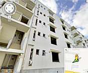
As part of an ongoing project to digitally archive the aftermath of the 2011 tsunami in northeastern Japan, Google has published several new panoramic images that provide a sobering glimpse of the widespread
devastation in communities across the region. The images, taken with the company’s Street View technology in four cities in the TÅhoku region, allows users to take a virtual tour of seriously damaged buildings before they are demolished. One panoramic view of a public housing project illustrates the height of the tsunami wave, which ruined everything up to the fourth floor of the building. Another image, of the condemned Ukedo Elementary School, shows the collapsed auditorium floor beneath the banner of a graduation ceremony that was never held. The images were added to Google’s “Memories for the Future” website, which is chronicling the affected areas from before and after the tsunami.
Google Images Document Devastation of 2011 Tsunami in Japan
More From E360
-
Energy
Facing a Hostile Administration, U.S. Offshore Wind Is in Retreat
-
Biodiversity
As Jaguars Recover, Will the Border Wall Block Their U.S. Return?
-
WATER
An E.U. Plan to Slash Micropollutants in Wastewater Is Under Attack
-
INTERVIEW
This Data Scientist Sees Progress in the Climate Change Fight
-
Climate
As Floods Worsen, Pakistan Is the Epicenter of Climate Change
-
Climate
Heat Stress Is a Major Driver of India’s Kidney Disease Epidemic
-
Energy
It’s a ‘Golden Age’ for U.S. LNG Industry, But Climate Risks Loom
-
Climate
How Climate Risks Are Putting Home Insurance Out of Reach
-
INTERVIEW
Inside the Plastics Industry Playbook: Delay, Deny, and Distract
-
Biodiversity
Freeing Captive Bears from Armenia’s Backyards and Basements
-
Food & Agriculture
In Indonesia’s Rainforest, a Mega-Farm Project Is Plowing Ahead
-
FILM CONTEST WINNER
In the Yucatan, the High Cost of a Boom in Factory Hog Farms