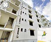
As part of an ongoing project to digitally archive the aftermath of the 2011 tsunami in northeastern Japan, Google has published several new panoramic images that provide a sobering glimpse of the widespread
devastation in communities across the region. The images, taken with the company’s Street View technology in four cities in the TÅhoku region, allows users to take a virtual tour of seriously damaged buildings before they are demolished. One panoramic view of a public housing project illustrates the height of the tsunami wave, which ruined everything up to the fourth floor of the building. Another image, of the condemned Ukedo Elementary School, shows the collapsed auditorium floor beneath the banner of a graduation ceremony that was never held. The images were added to Google’s “Memories for the Future” website, which is chronicling the affected areas from before and after the tsunami.
Google Images Document Devastation of 2011 Tsunami in Japan
More From E360
-
Oceans
As Ocean Waters Warm, a Race to Breed Heat-Resistant Coral
-
Energy
Will Hydrogen Hubs Be a Clean Energy Boom or Boondoggle?
-
BIOECONOMY
Brazil Hopes to Make the Amazon a Model for a Green Economy
-
INTERVIEW
How to Grow a Forest: It Takes More Than Just Planting Trees
-
Solutions
Greening Concrete: A Major Emitter Inches Toward Carbon Neutrality
-
INTERVIEW
As Disinformation Swirls, Meteorologists Are Facing Threats
-
Biodiversity
Ukraine Rewilding: Will Nature Be Allowed to Revive When War Ends?
-
Oceans
Researchers Parse the Future of Plankton in an Ever-Warmer World
-
Climate
What’s Causing the Recent Spike in Global Temperatures?
-
Biodiversity
How Traffickers Got Away with the Biggest Rosewood Heist in History
-
INTERVIEW
Why We Need a Strong Global Agreement on Plastics Pollution
-
Food & Agriculture
On Navajo Lands, Ancient Ways Are Restoring the Parched Earth
