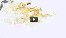
A new animation developed by researchers at the University of Hawaii’s International Pacific Research Center illustrates the likely path of the spreading field of debris caused by retreating waves from last year’s gigantic tsunami in Japan. The model —
based on satellite data and a network of scientific buoys showing sea surface height, ocean surface winds, and ocean currents — shows that debris swept into the Pacific by the event now likely stretches across an area covering 5,000 kilometers by 2,000 kilometers. Much of the debris was initially pulled by the strong Kuroshio Current, which travels past eastern Japan before shifting east and then into the North Pacific Current. The Japanese government estimates about 5 million tons of debris was pulled into the ocean; about 70 percent sank to the seafloor, with about 1.5 million tons still floating.
Model Shows Debris Field In Pacific From Japanese Tsunami
More From E360
-
ANALYSIS
Carbon Offsets Are Failing. Can a New Plan Save the Rainforests?
-
Energy
Facing a Hostile Administration, U.S. Offshore Wind Is in Retreat
-
Biodiversity
As Jaguars Recover, Will the Border Wall Block Their U.S. Return?
-
WATER
An E.U. Plan to Slash Micropollutants in Wastewater Is Under Attack
-
INTERVIEW
This Data Scientist Sees Progress in the Climate Change Fight
-
Climate
As Floods Worsen, Pakistan Is the Epicenter of Climate Change
-
Climate
Heat Stress Is a Major Driver of India’s Kidney Disease Epidemic
-
Energy
It’s a ‘Golden Age’ for U.S. LNG Industry, But Climate Risks Loom
-
Climate
How Climate Risks Are Putting Home Insurance Out of Reach
-
INTERVIEW
Inside the Plastics Industry Playbook: Delay, Deny, and Distract
-
Biodiversity
Freeing Captive Bears from Armenia’s Backyards and Basements
-
Food & Agriculture
In Indonesia’s Rainforest, a Mega-Farm Project Is Plowing Ahead