Water rings Rotterdam, the Netherlands’ second-largest largest city, at the confluence of the Rhine, Meuse, and Scheldt rivers, about 19 miles from the North Sea. Merchants founded the city, now Europe’s largest port. But the water that has long favored Rotterdam also threatens it. Ninety percent of the city sits below sea level. A band of dikes snakes along the city’s shoreline, a reminder of storm surges that could flood Rotterdam at any time.
Hamburg, Europe’s second-largest port, sits in an inland delta of the Elbe River. Cargo ships stacked high with red, orange, and blue containers glide up the Elbe, close by downtown. Settlers and conquerors built Hamburg on low bluffs above the north bank. It’s largely free of flood danger. But neighborhoods at the base of the plateau and on a few islands are at or below sea level.
Residents of these two great port cities have battled water for centuries. Floods have devastated property and, at times, drowned people by the hundreds. Out of their ruins, the vulnerable cities have learned how to cope with the ever-present risk of flooding. But, according to Henk Ovink, Special Envoy for International Water Affairs for the Netherlands, “fighting water is a war you never win,” and that is especially true today considering that global sea levels are projected to rise at least three feet this century.
“Societies all over,” says Ovink, “have to rethink.”
Germany and the Netherlands are leaders in flood control strategies and expertise, but other nations looking to them for help will find no easy solutions. These two countries are beefing up time-tested flood barriers such as dikes and sluice gates, as shown in these striking aerial photographs by Alex MacLean. But these upgrades can be enormously expensive and take a high environmental toll on shoreline ecosystems.
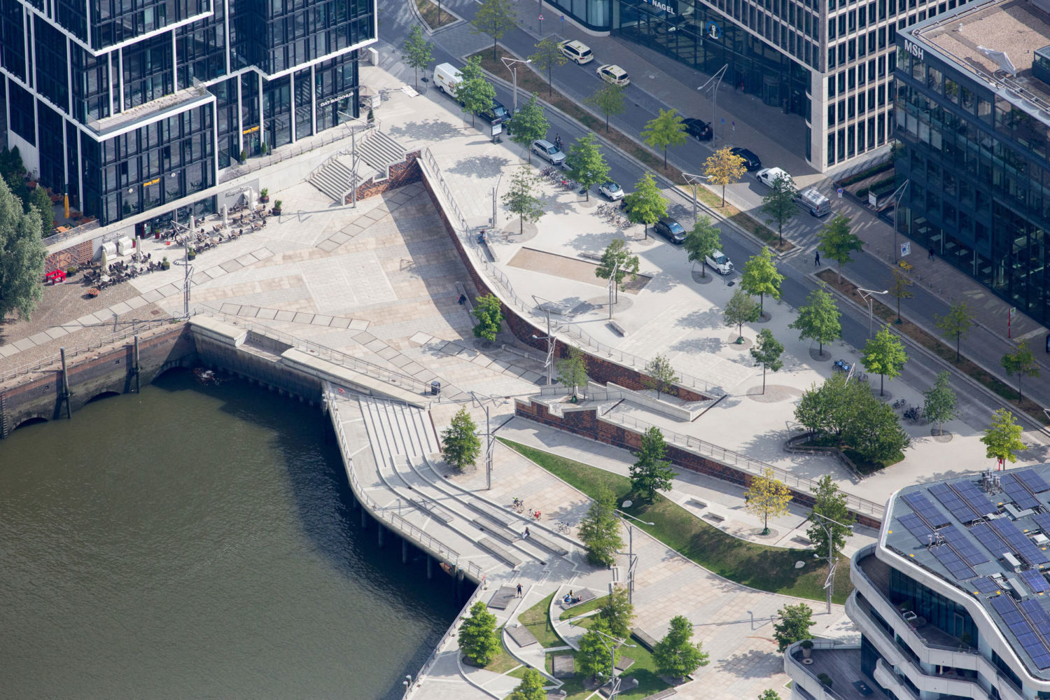
The HafenCity district of Hamburg, Germany, with a raised promenade and an elevated roadway behind it. View gallery.
Today, German and Dutch coastal planners and engineers are trying out new ideas that can fortify coastlines at lower financial and environmental cost. They’re experimenting with the science of “building with nature,” the practice of domesticating natural forces like wind and water, as well as using natural material such as sand and vegetation, to hold back the sea. But these approaches, too, are costly and could exact their own environmental toll.
Many coastal protection officials around the world have been soliciting advice and expertise from experts in the Netherlands. After Superstorm Sandy devastated the coastline of New York and New Jersey in 2012, for example, U.S. officials hired Ovink to help plan future flood control measures.
Experts note that while the Netherlands, Germany, the United States, and other industrialized nations have the means to confront, if not overcome, rising sea levels and higher storm surges, countries in the developing world — from Cairo to Bangladesh — generally do not. And one of the most important discussions taking place at United Nations climate talks in Paris next month will be exactly how much aid industrialized nations will provide poorer countries in their battle to hold back the sea.
Hamburg: New Flood-Protection Innovations
On November 9, 2007, a North Sea gale pitched a tide almost 18 feet above normal on the German coast, sending a surge of water that rushed all the way to Hamburg, 56 miles inland. The port closed and a torrent washed through low-lying quarters. But one neighborhood under construction on two river islands, HafenCity, stayed dry thanks to an innovative flood protection program.
Thorsten Gödtel, an urban planner, watched as the waters rose in HafenCity. Sitting in a café, Gödtel felt as safe as if he were peering into an aquarium, even though silty water swirled halfway up the restaurant’s extra-thick windows, inches from his aquiline nose. He left the restaurant on an elevated roadway, keeping his feet dry.
About two decades ago, city officials realized that the islands, then a warehouse and industrial district near the city center, could be better used. But, says Gödtel — who leads tours of the project — storm tides flooded the islands. Ringing their six miles of shoreline with dikes would have been prohibitively expensive and would have ruined the view.
Instead, planners created a special development zone, razed the old buildings and specified flood-related rules for new ones. The city built the roads and open public spaces on terraces of sand more than 25 feet above normal high tide. HafenCity’s shoreline was left at its original elevation, just above high tide. Developers were permitted to build at this level, but were required to waterproof the structures all the way up to, and have entrances at, the higher street level.
Now about 30 percent complete, HafenCity is home to about 2,000 residents and has 10,000 people working in the neighborhood. A flood barreling up the Elbe “feels more like an event,” than a disaster, says Gödtel. He acknowledges that other cities would find it hard to elevate land to avoid flooding, and says its expensive design was made possible by its prime location near downtown.
The city’s Wilhelmsburg section — an almond-shaped island of about 55,000 inhabitants south of HafenCity — doesn’t have the luxury of raising roads and flood-proofing buildings. Some of Wilhelmsburg sits 22 feet below sea level, and the neighborhood relies on earthen dikes for protection. “Without dikes,” says Henning Cordes — a “Dike Lord,” or elected official, who monitors flood protection — “Wilhelmsburg would be under water twice a day.”
Wilhelmsburg’s existing dikes were raised by nearly five feet in the 1960s following a disastrous 1962 storm that breached the dikes and killed 300 people. The city is currently building up dikes an additional 2.6 feet, a costly renovation that should keep Wilhelmsburg safe till mid-century. City officials haven’t decided what they’ll do next. Earthen dikes need several feet of additional width for every foot of added height, requiring more land than Wilhelmsburg can spare. “We have to look for other solutions,” says Cordes.
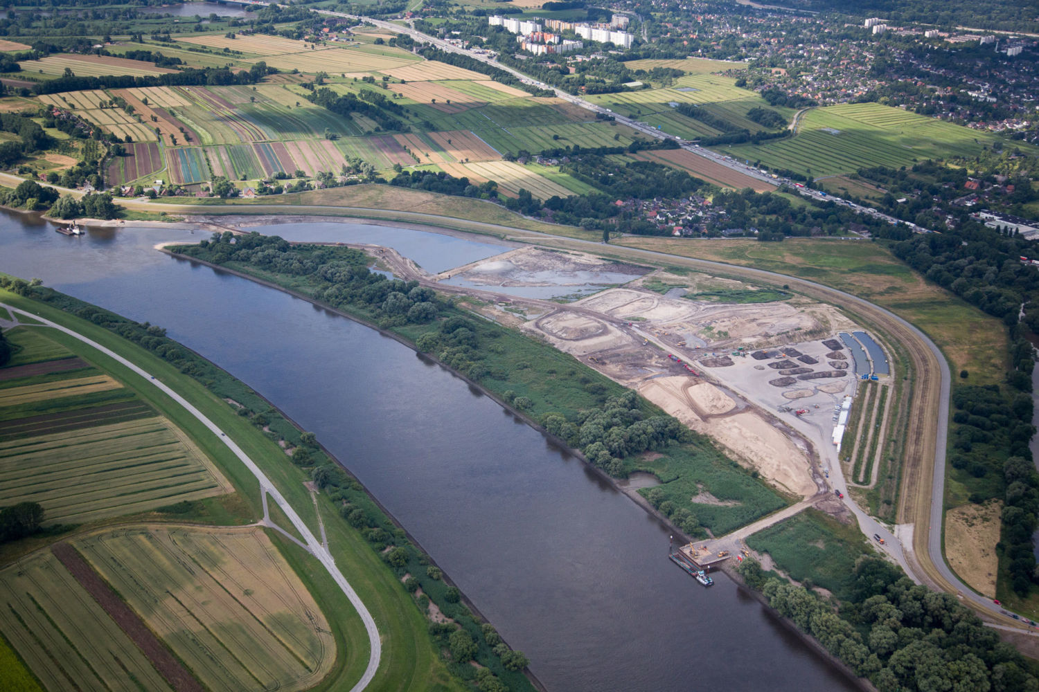
This embayment near the Wilhemsberg section of Hamburg was created to allow in river water and slightly relieve flooding. View gallery.
One option is to rely more heavily on so-called “building with nature” techniques, which seek to enhance natural buffers — such as dunes and floodplains — to turn back rising waters. In 2012, for example, backhoes broke through a bank separating the Elbe from a crescent-shaped marsh on Wilhelmsburg. River water gushed through the channel, creating a cove and adding 75 acres to the floodplain. The experimental basin slightly lowers the peak height of a storm surge.
Antje Stokman, director of the Institute of Landscape Planning and Ecology at Stuttgart University, advocates river widening on a much larger scale, using low-lying valleys that run parallel to the river downstream from Hamburg as flood relief valves. “We have to think of ways to create more flood plains — more space for the river — not just raise the dikes,” says Stokman.
Hans Von Storch, director emeritus of the Institute for Coastal Research in Geesthacht, Germany, has examined alternatives to higher dikes, including flood-plain augmentation. He says that such solutions would entail daunting economic and political obstacles. “People would revolt,” he said, if Hamburg tried to fortify itself by converting low-lying agricultural land into retention basins.
Rotterdam: Beyond Dikes and Barriers
As with Hamburg, a catastrophic flood haunts and reshaped Rotterdam. On January 31st, 1953 a powerful storm struck the Netherlands. Scores of dikes breached, swamping nearly 340,000 acres and killing 1,800 people.
After the disaster, the Dutch government designed the Delta Works, a far-reaching construction program to prevent a repeat. Instead of reinforcing thousands of miles of dikes lining flood-prone rivers and tributaries, the plan called for building robust dike-rings around large swaths of territory and the damming of bays with huge flood gates. The largest, most densely populated zone, Dike Ring South Holland, or Dike Ring 14, would encircle Rotterdam, Amsterdam, and other urban areas.
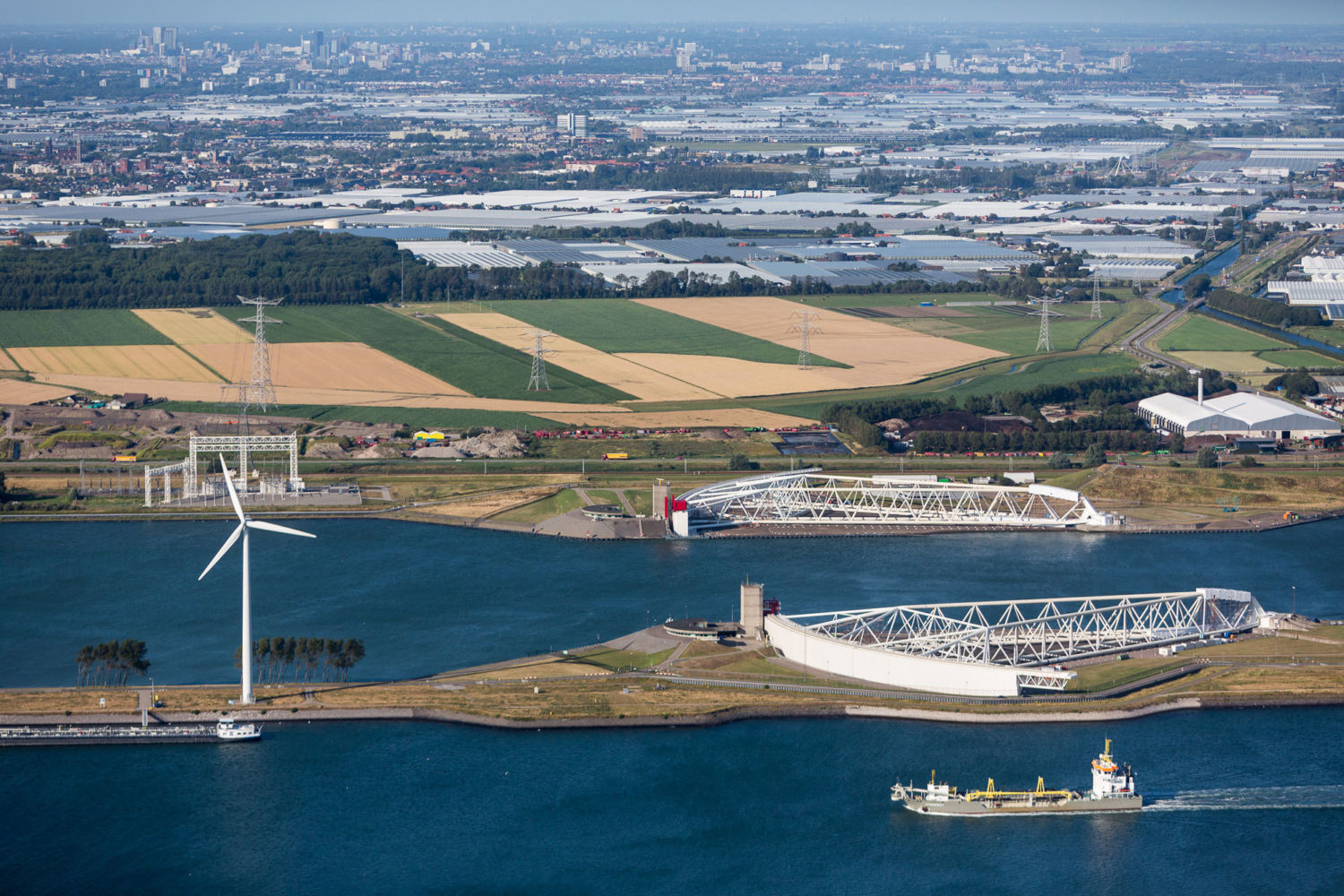
The massive gates of the Maeslant Barrier can be closed to protect Rotterdam and other areas from storm surges. View gallery.
The Delta Plan’s capstone, the Maeslant Barrier, is a movable storm gate at the mouth of the Rhine. When a storm surge reaches 9.8 feet above normal sea level, the structure’s two massive doors swing on pivots from opposite shores, meeting mid-stream like hands clasping. They’re among the largest moving objects on Earth, each 787 feet long and weighing 15 million pounds. Following Superstorm Sandy, some engineers proposed building similar gates across the Verrazano Narrows to protect New York City.
Jan Mulder, a coastal engineer for the big Dutch water consulting firm Deltaressays dikes have become pervasive visual barriers, a problem worsening every time they’re raised. He said that the Delta Works also caused serious ecological damage to the coast. It completely cut off three branches of a large estuary from the sea with impermeable floodgates, transforming them into artificial freshwater lakes. The fish, shellfish, and marsh grass that lived there have disappeared. Algal blooms have plagued the water bodies. Even the Easterscheldt Barrier, which allows some tidal flow, has seriously degraded the wetlands behind it.
“The technological approach has not brought us a sustainable solution,” says Mulder.
To keep Rotterdam and other nearby land safe in the face of sea level rise, engineers will need to beef up the seacoast, where a nearly continuous strip of sand dunes holds the sea back, says Mindert de Vries, another Deltares engineer. Like Mulder, De Vries proselytizes for “building with nature.” Instead of steel, concrete, and packed clay, he’d like to see more sand and marsh grass used to protect coastlines. He’d also like to use natural forces, such as wind and currents, rather than heavy earthmoving equipment, to move protection into place. The most important example today is called the Sand Engine, which involves dumping dredged sand offshore of the coastal dune fields, stabilizing the coast by preventing waves from eroding the shore.
Crews started holding the coastline in place with sediment dredged from the North Sea in the 1990s. Initially they dumped about 200 million cubic feet of sand a year — more than two times the volume of the Giant Pyramid of Giza. In 2008 the government’s flood protection advisory body concluded that to keep up with sea level rise through 2050, the country must distribute 3 billion cubic feet of sand a year along 200 miles of coastline. Researchers are still trying to figure out how to economically move this vast volume of material.

Beach stabilization projects and a dike behind the sand protect a town in the northern Netherlands.View gallery.
Arriving in his car at Ter Heijde, a resort town on the coast, Mulder gestures to a curved peninsula of light brown sand stretching into the sea like a bent arm flexing a muscle — the Sand Engine. In 2011 researchers deposited 750 million cubic feet of sand here in a half-mile swath. They project that the powerful winds and racing currents around Ter Heijde will spread the material out along six miles of shoreline over 20 years. Some scientists worry that such massive movement of sediment could harm coastal wildlife, but Mulder says the experiment includes careful ecological monitoring for problems.
Mulder says that the mass has already spread more than two miles since the experiment began. “The redistribution process,” he says, “is going very well.”
Is Coastal Retreat Inevitable?
In the coming years, many more cities will take up the struggle that has preoccupied Hamburg and Rotterdam for more than 1,000 years. Last year, the U.S. Department of Housing and Urban Development announced seven plansfor protecting the New Jersey and New York shores from storms like Sandy, and allocated almost $1 billion in initial funding. Five of the funded projects — which included the use of dikes, rejuvenated marshes to slow storm surges, and natural basins for temporary storage of storm waters — were submitted by groups that included Dutch engineering and design firms.
And what of cities and nations lacking the financial resources of Hamburg, Rotterdam, or New York? Experts say they will either have to receive massive financial assistance from the developed world, or retreat from the coasts. Jan Mulder says that, up to a point, “building with nature” techniques could be an effective and economical way for developing countries to protect their coastlines. For instance, restored mangrove forests on the coast of India and Bangladesh could slow destructive wave action and trap sediment, helping to elevate the shoreline as the sea rises.
But Klaus Jacob, a research scientist at Columbia University’s Lamont-Doherty Earth Observatory, says that society is still woefully unprepared for sea level increases later this century that will spare neither industrialized nor developing nations.
“We are still in denial that we can engineer ourselves out of this,” says Jacob. “The only truly reliable solution is retreating from low-lying areas.”
VIEW GALLERY
Author Daniel Grossman and photographer Alex MacLean received support for this project from the Pulitzer Center on Crisis Reporting and the Whole Systems Foundation.