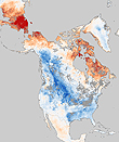
This NASA satellite map shows how a major change in Arctic air currents has led to topsy-turvy weather across North America, with temperatures far below normal in the U.S. and western Canada and extreme warmth affecting many Arctic regions. The red and blue colors represent to what degree recent temperatures have been above or below the norm, as measured by instruments aboard NASA’s Aqua satellite. The bizarre weather has occurred because a climate pattern known as the Arctic Oscillation, which occurs because of differences in air pressure between the Arctic and mid-latitudes, has shifted into a negative phase. That means the pressure gradient has weakened, enabling Arctic air to pour south and warm air to slip north. The NASA map shows that large swaths of Alaska and Canada have experienced temperatures as much as 18 degrees C (32 F) above normal, while much of the U.S. has experienced unusually cold temperatures and frequent snowstorms. While residents of the eastern seaboard have faced a battery of winter storms, residents in Iqualit, capital of the Canadian territory of Nunavut, were forced to cancel their New Year’s snowmobile parade.
Change in Arctic Oscillation Chills North America and Warms Arctic
More From E360
-
OPINION
Trump’s Logging Push Thrusts a Dagger at the Heart of Wilderness
-
INTERVIEW
Pakistan’s Solar Revolution Is Bringing Power to the People
-
Food & Agriculture
In Uganda, Deadly Landslides Force an Agricultural Reckoning
-
Energy
Why U.S. Geothermal May Advance, Despite Political Headwinds
-
Food & Agriculture
In War Zones, a Race to Save Key Seeds Needed to Feed the World
-
Climate
Lightning Strikes the Arctic: What Will It Mean for the Far North?
-
RIVERS
A Win for Farmers and Tribes Brings New Hope to the Klamath
-
Solutions
Deconstructing Buildings: The Quest for New Life for Old Wood
-
NATURAL DEFENSES
How Restored Wetlands Can Protect Europe from Russian Invasion
-
Solutions
Birds vs. Wind Turbines: New Research Aims to Prevent Deaths
-
Biodiversity
Cambodian Forest Defenders at Risk for Exposing Illegal Logging
-
OPINION
The ‘Green’ Aviation Fuel That Would Increase Carbon Emissions