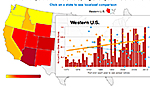
An interactive tool produced by the group Climate Central illustrates how rising temperatures and reduced snowpack in the western U.S. have corresponded with an increase in wildfiresin recent decades. Based on
federal wildfire data from 1970 to 2012, the graphic shows how large fires in some western states — including Arizona, Colorado, and Idaho — have doubled or even tripled in four decades, a period when the average spring and summer temperatures in 11 states increased by more than 1.5 degrees F. According to the Climate Central analysis, Arizona has experienced the highest average increase in spring temperatures, about 1 degree F, which has likely been a key factor in the steep increase in fires covering more than 1,000 acres. Another key factor has been the decrease in mountain snowpack. During several seasons, unusually low amounts of spring snow caused extended droughts that helped drive more big fires.
Map Shows Possible Link Between Warmer Springs and Large Fires
More From E360
-
Energy
A Home Battery Revolution Is Reshaping the Power Grid
-
Energy
In East Africa, a Controversial Oil Project Is Poised for Production
-
Climate
A Missing Piece in Climate Models: Nature’s Own Emissions
-
INTERVIEW
An EPA Researcher Details the Agency’s Assault on Science
-
Oceans
Efforts to Save Kelp Forests from Ocean Warming Are Ramping Up
-
Biodiversity
Pollution Is Changing the Smells of Nature, With Risks for Wildlife
-
Oceans
Supertrawlers Are Taking Antarctic Krill That Whales Depend On
-
INTERVIEW
The U.S. Senator Who Won’t Shut Up about Climate Change
-
Energy
A First Among Major Nations, India Is Industrializing With Solar
-
A NOTE FROM THE EDITOR
After Two Decades, E360’s Founder and Editor Is Moving On
-
Solutions
Restoring the Flow: A Milestone in the Revival of the Everglades
-
Climate
Why Fears Are Growing Over the Fate of a Key Atlantic Current