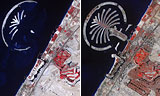
In these photographs, NASA satellites capture the explosive growth of Dubai on the Persian Gulf between 2002 and 2008. These false-color thermal images of Dubai — one of the 7 United Arab Emirates — depict vegetated areas in red, buildings in gray, and the desert in beige. The image at left, taken in October 2002, shows the early stages of construction of Palm Jumeirah, a vast commercial development built by dredging 3.9 billion cubic feet of sand from the gulf and depositing it in the shape of a giant palm tree. The finished look of Palm Jumeirah — which contains shops, hotels, and apartments and is protected from the gulf by 7 miles of rocky breakwater — can be seen in the image at right, taken in November 2008. That recent image also shows the exponential growth of Dubai, a city-state of 1.2 million and a major commercial hub in the oil-rich Persian Gulf region. Just to the east of Palm Jumeirah, the fairways of an irrigated golf course, pictured in red, can be seen.
Dubai’s Urban Sprawl
More From E360
-
Cities
In Steel Country, the Fight for Clean Air Faces New Obstacles
-
Solutions
Beyond Lithium: New Battery Tech Starts to Break Through
-
INTERVIEW
What Do We Actually Know About the Microplastics Inside Us?
-
Energy
A Home Battery Revolution Is Reshaping the Power Grid
-
Energy
In East Africa, a Controversial Oil Project Is Poised for Production
-
Climate
A Missing Piece in Climate Models: Nature’s Own Emissions
-
INTERVIEW
An EPA Researcher Details the Agency’s Assault on Science
-
Oceans
Efforts to Save Kelp Forests from Ocean Warming Are Ramping Up
-
Biodiversity
Pollution Is Changing the Smells of Nature, With Risks for Wildlife
-
Oceans
Supertrawlers Are Taking Antarctic Krill That Whales Depend On
-
INTERVIEW
The U.S. Senator Who Won’t Shut Up about Climate Change
-
Energy
A First Among Major Nations, India Is Industrializing With Solar