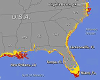
Rising sea levels could inundate 9 percent of the land within 180 U.S. cities by 2100, with cities along the Gulf of Mexico and the south Atlantic coast facing the most critical threats, according to a new study. Using elevation data from the U.S. Geological Survey, researchers at the University of Arizona created digital maps of the U.S. coast that delineate the areas that would be affected if seas rise three feet this century and up to 20 feet in subsequent centuries as ice sheets and glaciers melt worldwide. According to the projections, Miami, New Orleans, Tampa, Fla., and Virginia Beach, Va. could lose 10 percent of their land area to rising seas by the end of the century. If sea levels rise 10 feet, more than 20 percent of the land in these cities would be inundated. And if sea levels increase 20 feet in subsequent centuries, about one-third of the land area of U.S. coastal cities will be affected, according to the study, to be published in the journal Climatic Change Letters. As the maps illustrate, not only oceanfront property will be affected by rising waters, but also land connected to the sea by channels, creeks, inlets, and nearby low-lying areas.
Future Effects of Rising Seas Depicted for U.S. in New Study and Map
More From E360
-
SPACE
Scientists Warn of Emissions Risks from the Surge in Satellites
-
WILDLIFE
A Troubling Rise in the Grisly Trade of a Spectacular African Bird
-
MINING
In Myanmar, Illicit Rare Earth Mining Is Taking a Heavy Toll
-
INTERVIEW
How Batteries, Not Natural Gas, Can Power the Data Center Boom
-
ANALYSIS
As U.S. and E.U. Retreat on Climate, China Takes the Leadership Role
-
Solutions
From Ruins to Reuse: How Ukrainians Are Repurposing War Waste
-
ANALYSIS
Carbon Offsets Are Failing. Can a New Plan Save the Rainforests?
-
Energy
Facing a Hostile Administration, U.S. Offshore Wind Is in Retreat
-
Biodiversity
As Jaguars Recover, Will the Border Wall Block Their U.S. Return?
-
WATER
An E.U. Plan to Slash Micropollutants in Wastewater Is Under Attack
-
INTERVIEW
This Data Scientist Sees Progress in the Climate Change Fight
-
Climate
As Floods Worsen, Pakistan Is the Epicenter of Climate Change