Forty-three hurricane-force winter storms have lashed the North Atlantic since late October, boosting the region’s average wind speed in January and February by more than 12 miles per hour, as shown in this map from
the U.S. National Oceanic and Atmospheric Administration (NOAA). The blue colors indicate areas where wind speeds exceeded the 1981-2010 average; browns indicate winds that were lower than average. In the North Atlantic, an unusually high number of hurricane-force storms, with winds exceeding 74 mph, battered southeastern Greenland, Norway, and the coast of western Europe. The U.K. Met Office recently issued a report on the December and January storms that ravaged the British coast, saying, “For England and Wales this was one of, if not the most, exceptional (two month) periods of winter rainfall in at least 248 years.” No studies have confirmed a link between these intense winter storms and climate change, but some scientists think climate-driven changes in the jet stream may be behind the wild weather.
Click to Enlarge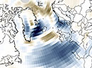
January-February wind speed anomalies