Durham University
Map Of Arctic Claims
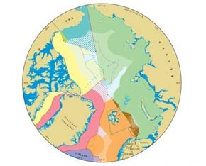
This map shows territorial claims being made by the nations surrounding the Arctic Ocean; such claims have assumed greater importance as Arctic sea ice melts and surrounding countries intensify efforts to exploit natural resources. Developed by researchers at the International Boundaries Research Unit at Durham University in the U.K., the map shows the accepted claims of the Arctic nations — those within their 200-mile territorial limits, or Exclusive Economic Zone (EEZ) — and disputed claims, shown in the center in shaded areas. A key area of dispute are claims to resources on continental shelves beyond the EEZ. Russia’s territorial seas are shown in green, Canada’s in yellow, the U.S.’s in aqua blue, Norway’s in orange, Iceland’s in purple, and Denmark’s in pink. For a high-resolution map and detailed notes, click here.
More From E360
-
INTERVIEW
Marina Silva on Brazil’s Fight to Turn the Tide on Deforestation
-
Solutions
Solomon Islands Tribes Sell Carbon Credits, Not Their Trees
-
INTERVIEW
With Sea Turtles in Peril, a Call for New Strategies to Save Them
-
RIVERS
Jared Kushner Has Big Plans for Delta of Europe’s Last Wild River
-
Energy
A Nuclear Power Revival Is Sparking a Surge in Uranium Mining
-
OPINION
Despite Official Vote, the Evidence of the Anthropocene Is Clear
-
INTERVIEW
At 11,500 Feet, a ‘Climate Fast’ to Save the Melting Himalaya
-
Oceans
Octopuses Are Highly Intelligent. Should They Be Farmed for Food?
-
Climate
Nations Are Undercounting Emissions, Putting UN Goals at Risk
-
Solutions
As Carbon Air Capture Ramps Up, Major Hurdles Remain
-
ANALYSIS
How China Became the World’s Leader on Renewable Energy
-
Biodiversity
As Flooding Increases on the Mississippi, Forests Are Drowning