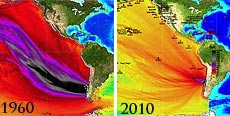
These images vividly illustrate that the tsunami waves generated by the recent Chilean earthquake were far less severe than the waves created by a massive earthquake in Chile in 1960, the largest quake ever recorded. A model created by the National Atmospheric and Oceanographic Agency’s Center for Tsunami Research in the hours after the recent earthquake, which measured 8.8 on the Richter Scale, provided an accurate forecast of the relatively mild tsunami waves that eventually reached Hawaii and other Pacific coastal communities. Using seismic information, wave measurements collected from buoy-based equipment, and computer modeling technology, NOAA was able to forecast the maximum wave amplitude, wave arrival time, and the extent of wave inundation. The image, at right, shows the power of the tsunami waves from the recent quake, with larger waves in red and orange and smaller waves in yellow. Using historical data, NOAA researchers used the same software to illustrate the extent of a tsunami triggered by the 1960 quake — 9.5 on the Richter Scale — whose tsunami waves killed 61 people in Hawaii and another 185 in Japan. The image at left shows the power of the 1960 quake, with extremely large waves depicted in black, gray, and purple. The image shows that high waves, in dark red, swept across the entire Pacific following the 1960 quake.
Model of Chilean Tsunamis
More From E360
-
Cities
In Steel Country, the Fight for Clean Air Faces New Obstacles
-
Solutions
Beyond Lithium: New Battery Tech Starts to Break Through
-
INTERVIEW
What Do We Actually Know About the Microplastics Inside Us?
-
Energy
A Home Battery Revolution Is Reshaping the Power Grid
-
Energy
In East Africa, a Controversial Oil Project Is Poised for Production
-
Climate
A Missing Piece in Climate Models: Nature’s Own Emissions
-
INTERVIEW
An EPA Researcher Details the Agency’s Assault on Science
-
Oceans
Efforts to Save Kelp Forests from Ocean Warming Are Ramping Up
-
Biodiversity
Pollution Is Changing the Smells of Nature, With Risks for Wildlife
-
Oceans
Supertrawlers Are Taking Antarctic Krill That Whales Depend On
-
INTERVIEW
The U.S. Senator Who Won’t Shut Up about Climate Change
-
Energy
A First Among Major Nations, India Is Industrializing With Solar