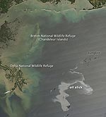
A new image taken by a NASA satellite captures the extent of a major oil spill triggered by the explosion aboard an offshore oil rig about 40 miles off the Louisiana coast in the Gulf of Mexico. An estimated 42,000 gallons of oil have been gushing into Gulf waters daily since the Deepwater Horizon exploded and sank to the sea floor last week. Eleven crew members were killed in the blast, and several others were injured, and experts say the spill threatens the marine environment across the region, particularly on the Chandeleur and Breton barrier islands in Louisiana, where thousands of birds are nesting. Oyster beds on the eastern edge of the Mississippi River also are threatened. In this image, taken by NASA’s Aqua satellite, the swirling sheen of oil — roughly 50 miles long and 33 miles wide — is seen in the lower right corner. Northerly winds have blown the slick away from the coast, but the wind direction is expected to shift Thursday and drive the slick toward the Louisiana wetlands.
NASA Image Captures Extent of Oil Leak off U.S. Gulf Coast
More From E360
-
WILDLIFE
A Troubling Rise in the Grisly Trade of a Spectacular African Bird
-
MINING
In Myanmar, Illicit Rare Earth Mining Is Taking a Heavy Toll
-
INTERVIEW
How Batteries, Not Natural Gas, Can Power the Data Center Boom
-
ANALYSIS
As U.S. and E.U. Retreat on Climate, China Takes the Leadership Role
-
Solutions
From Ruins to Reuse: How Ukrainians Are Repurposing War Waste
-
ANALYSIS
Carbon Offsets Are Failing. Can a New Plan Save the Rainforests?
-
Energy
Facing a Hostile Administration, U.S. Offshore Wind Is in Retreat
-
Biodiversity
As Jaguars Recover, Will the Border Wall Block Their U.S. Return?
-
WATER
An E.U. Plan to Slash Micropollutants in Wastewater Is Under Attack
-
INTERVIEW
This Data Scientist Sees Progress in the Climate Change Fight
-
Climate
As Floods Worsen, Pakistan Is the Epicenter of Climate Change
-
Climate
Heat Stress Is a Major Driver of India’s Kidney Disease Epidemic