A pair of satellite images taken four decades apart shows the shifting ecological landscape of the Siberian Arctic, where warming temperatures have enabled a swath of thick shrubs to thrive in once-open tundra. The
photos, posted by the NASA Earth Observatory, show the fundamental shift that occurred in a lake-covered region near Russia’s Yennisey River between 1966 and 2009. In the 1966 image — a declassified spy satellite photo — the region between lakes is visibly open tundra. By 2009, thick shrubs had colonized the entire area, a shift that scientists say has triggered a cascade of ecological changes, including the loss of plant diversity and a more difficult landscape for deer and caribou to forage. Whether the spread of the shrubs will accelerate or slow the melting of the region’s permafrost — an outcome that could have global impacts if large amounts of methane are released — depends on the balance of two competing effects: Shrubs provide shade in summer, keeping permafrost cooler, but they also trap snow and warmth in winter, raising the temperature of permafrost.
Click to enlarge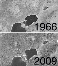
NASA
Siberian Arctic, 1966 to 2009