European scientists have developed an algorithm using satellite imagery to more accurately monitor the Earth’s boreal forest biomass inventory, a resource they say will help them better understand the carbon 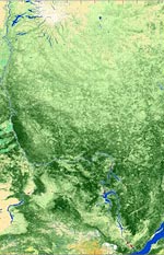 cycle and predict future climate. Using images from the European Space Agency’s Envisat satellite, researchers say they are able to retrieve information on forest growing stock volume — the amount of wood in cubic meters per hectare — at resolutions never before possible, even when the forest is covered in darkness or clouds, a step toward what they call the world’s first global biomass “map.” Scientists say protecting boreal, or northern, forest is one of the best defenses against a warming climate since it stores a third more carbon per hectare than tropical forests. Boreal forest, which consists of swamps, peatlands, and forests, covers about 14.5 percent of the planet’s surface — mostly in Canada and Russia. “Since no biomass maps exist with a high level of accuracy, we do not know how much is changing and cannot do calculations with any certainty,” said Christiana Schmullius of the Friedrich Schiller University Jena. The new algorithm may be the first step toward creating a global biomass map, which could help scientists more accurately model climate change and also help in monitoring forest fire prevention and forest management.
ESA/Friedrich-Schiller University Jena
Boreal forest in Central Siberia