A system of storms this month caused significant flooding in most of Death Valley National Park in southeastern California. These images,
obtained via a U.S. Geological Survey-NASA satellite, contrast the region’s moisture content in October 2015 and October 2014, which was a year with typical precipitation. The images have been enhanced with false color to highlight water at or near the surface of the earth; green and blue indicate locations with high moisture content. Especially striking is Badwater Basin, the lowest point in North America at an elevation of 279 feet below sea level, which is usually a dry lakebed. In the 2015 image, Badwater Basin is full of water. Flash floods from the so-called “1,000-year” flood event destroyed roads and utilities, and damaged several historical structures, according to the USGS.
Enlarge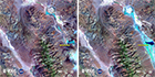
Flooding in Death Valley