The damming of its Tibetan rivers “effectively gives China a chokehold on India’s economy,” a report from independent experts says.
Some independent experts share the concern. Ameya Pratap Singh, a political scientist at the University of Oxford, said in a report that China’s damming of its Tibetan rivers “effectively gives China a chokehold on India’s economy” if tensions between the two nations escalate. But others urge caution. Ruth Gamble, an environmental historian at La Trobe University, in Australia, says that, despite the project’s huge electricity-generating potential, the dams won’t hold back large volumes of water, so the potential to inflict harm downstream will be limited.
Even so, the stakes are high, with tensions over scarce water resources in the region rising. India last month suspended its adherence to a treaty in operation for 65 years to share with Pakistan the waters of another great South Asian river, the Indus. Meanwhile the 30-year-old Ganges Water Treaty between India and Bangladesh is set to expire next year, with India widely accused of violating its terms.
“Weaponizing water is a perilous strategy that may backfire,” says Mehebub Sahana, an environmental geographer at the University of Manchester. “The weakening of water diplomacy in South Asia is not just a regional threat; it endangers global climate security.”
Tibet, part of China since 1951, is the water tower of Asia. Its vast glaciers sustain major rivers on which more than 1.3 billion people in 10 countries depend for drinking, irrigating crops, and hydropower. China, already the world’s leading producer of hydroelectricity, sees more dams on these rivers as a key to reducing its carbon emissions. It has already tapped the power of the Yellow and Yangtze rivers, which flow entirely within China, as well as several that flow beyond its borders, including the Mekong, Irrawaddy, and Salween. Now it is eyeing the Brahmaputra, the world’s ninth largest river.
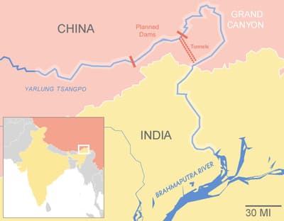
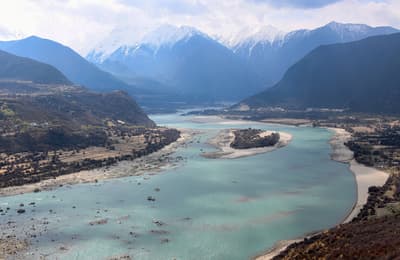
The Brahmaputra begins as meltwater from the Angsi Glacier in western Tibet. From there it flows east through the Himalayas, before turning sharply south, skirting Namcha Barwa mountain, and tumbling down waterfalls and rapids through the Yarlung Tsangpo Grand Canyon onto the plains of India and Bangladesh, before entering the Bay of Bengal through the world’s largest river delta.
In 2014, China completed its first hydroelectric dam on the river’s main stem, the 380-foot Zangmu Dam. But the rapid descent of the river at the Yarlung Tsangpo Grand Canyon has long been seen by dam engineers as the world’s most promising site for power generation. The formal go-ahead for the project there was announced on Christmas Eve 2024.
The strongest earthquake ever recorded on land happened just 300 miles away from the site of the planned dam project.
Technical details about the project have yet to be published. But Chinese government media say it will have a generating capacity of 60,000 megawatts, almost 30 times that of the Hoover Dam. But the two proposed dams don’t need to be even as high as the Hoover Dam, says Gamble. “This is more a mega-project than a mega-dam.” The site’s unique geography will do the work, as the water rushes downward for thousands of feet through 12-mile-long tunnels to deliver unprecedented power to turbines at the bottom of the canyon, before discharging the flow back into the river close to the border with India. “Indian soldiers will overlook the project from their bunkers,” says Gamble.
Indian scientists believe that operating the dams to meet China’s electricity needs will change the river’s strongly seasonal flow. “Reduced water flow in the dry season, coupled with sudden releases of water during monsoons, could intensify both water scarcity and flooding, endangering millions,” says Sahana.
The project could also impact sediment flows in the river. Erosion in the canyon currently supplies 45 percent of the total volume of sediment that flows downstream on the Brahmaputra, says Robert Wasson, a geomorphologist at James Cook University, in Australia. Bypassing the canyon could reduce sediment supply to the lower reaches and damage the river’s vast delta, says Sahana. “Any disruption to the balance of sediment could accelerate coastal erosion and make the already low-lying [delta] area more vulnerable to sea-level rise.” But this outcome is far from clear, says Wasson, as too little is known about sediment movement on the river.
Such impacts would be gradual. But there are also fears of more catastrophic outcomes. The dam site is on a boundary between two major tectonic plates in one of the world’s most seismically active regions. “If I were a Chinese planner, I would be most worried about a great earthquake” that could breach the dam, says Wasson. The strongest earthquake ever recorded on land, the magnitude 8.6 Assam-Tibet quake, happened in 1950 just 300 miles away.
Chinese officials insist that the dam will be safe and that its operation will have no deleterious effect on downstream countries or their ecology. State-employed academics have argued the dam could make the river safer by reducing peak flood flows. But Chinese researchers studying the region’s ecology have warned that, even though the project won’t inundate the canyon, safeguarding its natural wonders from the extensive activity from building and operating this massive construction project will require what Yu Ren, a geographer at Peking University, calls “urgent action to protect it.”
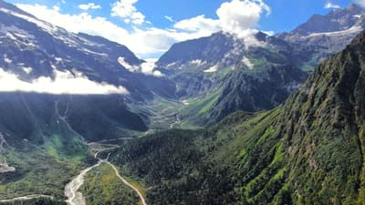
The Yarlung Tsangpo Grand Canyon is extremely remote and has rarely been explored by foreigners since 19th-century British plant hunters passed through looking for exotic species to fill their gardens back home. But Chinese ecologists have recently been trying to make up for lost time. The canyon is “one of China’s vital gene banks,” says Shuaifei Duan of the Chinese Academy of Sciences. It is a biodiversity hotspot created by the huge changes in elevation — some 20,000 feet from mountain top to canyon bottom — combined with wet monsoon air blowing into the canyon from the south. Within a few miles, it contains glaciated peaks, alpine meadows, pine forests, and tropical rainforests.
The canyon has ”the world’s largest assemblage of large carnivores,” including snow leopards, Bengal tigers, and Tibetan brown bears.
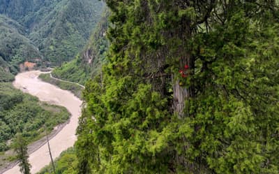
Researchers have documented more than 4,500 species of plants, and “China’s largest and most intact primary forest” containing Asia’s tallest tree, a native cypress more than 330 feet tall and believed to be a thousand years old. The canyon’s profuse animal life also includes “the world’s richest assemblage of large carnivores,” says Ren, with lynx, Tibetan brown bears, Asian black bears, gray wolves, and Asiatic wild dogs.
The canyon also has “more cat predators than anywhere else on the planet,” says Gamble — from snow leopards on the mountain to China’s only known Bengal tigers in the jungle below. On the slopes are Asian golden cats, jungle cats, marbled cats, clouded leopards, and common leopards.
Can this biological Shangri La survive an invasion of engineers and a giant construction project? Peking University geographer Guo Qinghua, Ren, and other colleagues have campaigned to turn the canyon into a national park. But Gamble says this is not enough on its own. It ignores the true custodians, the local Indigenous Adi and Monpa people, for whom the canyon and surrounding mountains and forests are sacred. “There seems to be minimal local engagement in conservation and no official recognition that the whole region is a sacred site,” she says.
A climber scales the tallest tree in Asia, a 335-foot cypress growing in the Yarlung Tsangpo Grand Canyon. Jigme Dorje / Xinhua via Getty Images
India has long had its own designs on damming the Brahmaputra. Now its desire for hydroelectricity has been combined with the urge to protect the country from the perceived risks posed by China’s project. After China’s Christmas Eve announcement, India’s water ministry revived a 2017 plan for an 11,000-megawatt dam on the river in Arunachal Pradesh, just downstream of the canyon. Known as the Siang Upper Multipurpose Project (SUMP), it would be India’s largest hydroelectric dam. “The SUMP is not just about generating power, but also about maintaining the natural flow of the… river and mitigating potential flood risks from water releases by China,” chief minister Khandu said.
But some experts say the proposed thousand-foot dam could have as great a detrimental environmental impact as the Chinese project. It “will require a large reservoir, produce less power and could potentially be more dangerous,” says Gamble. Local activists opposed to the dam say its reservoir would submerge more than 25 villages. Tensions seem set to rise, with protests and court cases pending.
The geopolitics of international rivers in South Asia has long been fraught. India itself has often been accused of being an upstream bully — notably on the Indus River, which flows out of the Himalayas and through India to Pakistan.
The power of upstream nations over their downstream neighbors is also central to the dispute between India and Pakistan over the Indus.
Ever since those two nations were divided on independence from the British in 1947, there have been heated disputes over access to the Indus’s water. Around 80 percent of Pakistan’s water come from the river, and the country has long feared that India will build dams to choke off its supply.
After two wars in which the Indus was in dispute, the World Bank in 1960 brokered the Indus Waters Treaty, under which India and Pakistan divided the water between them. But in 2008, India completed a giant hydroelectric dam, the 470-foot high Baglihar Dam, on one of the Indus tributaries whose water is designated under the treaty for Pakistan. The water still flows into Pakistan, but through Indian turbines and at a time of India’s choosing.
Last month, tensions soared again when India unilaterally suspended its adherence to the treaty, as part of its retaliation for a terrorist attack. Pakistan’s prime minister Shehbaz Sharif responded by warning that if India tried to block the river’s flow it would be met with “full force and might.”
The parallel between this standoff on the Indus and the threat posed to India by the Chinese project on the Brahmaputra is compelling, but not exact. There is no treaty governing the management of the Brahmaputra, for instance. But the power of upstream countries over their downstream neighbors is central to both disputes. In each case, the hydrological and political stakes are high in a region with a troubling history of belligerent rhetoric, unilateral actions on shared rivers, and taking up arms over disputed waters.
Correction, May 23, 2025: An earlier version of this article incorrectly stated that ocelots can be found in the Yarlung Tsangpo Grand Canyon. Ocelots are not found there.


