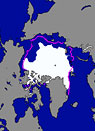
The extent of ice covering the Arctic Ocean reached its third-lowest level this summer since satellite observations began in 1979, rebounding from record lows in 2007 and 2008, according to the U.S. National Snow and Ice Data Center (NSIDC). Arctic sea ice, measured at its low point in September, covered an area of two million square miles last month — 649,000 square miles below the September average from 1979 to 2000. This year’s summer sea ice extent was nevertheless 409,000 square miles greater than the record low ice extent set in 2007. Ice extent grew this year, scientists say, because cloudy skies in late summer kept sea surface temperatures lower and because atmospheric patterns in August and September helped to spread out the ice pack. Despite the rebound in extent, ice thickness continues to decline, with only 19 percent of the ice cover more than two years old — far below the 1981 to 2000 average of 52 percent. Arctic sea ice is still declining at a rate of 11 percent per decade. “It’s nice to see a little recovery over the past couple years, but there’s no reason to think that we’re headed back to conditions seen back in the 1970s,” said NSIDC director and senior scientist Mark Serreze. “We still expect to see ice-free summers sometime in the next few decades.”
Arctic Sea Ice Extent At Third-Lowest Level Since 1979
More From E360
-
Cities
In Steel Country, the Fight for Clean Air Faces New Obstacles
-
Solutions
Beyond Lithium: New Battery Tech Starts to Break Through
-
INTERVIEW
What Do We Actually Know About the Microplastics Inside Us?
-
Energy
A Home Battery Revolution Is Reshaping the Power Grid
-
Energy
In East Africa, a Controversial Oil Project Is Poised for Production
-
Climate
A Missing Piece in Climate Models: Nature’s Own Emissions
-
INTERVIEW
An EPA Researcher Details the Agency’s Assault on Science
-
Oceans
Efforts to Save Kelp Forests from Ocean Warming Are Ramping Up
-
Biodiversity
Pollution Is Changing the Smells of Nature, With Risks for Wildlife
-
Oceans
Supertrawlers Are Taking Antarctic Krill That Whales Depend On
-
INTERVIEW
The U.S. Senator Who Won’t Shut Up about Climate Change
-
Energy
A First Among Major Nations, India Is Industrializing With Solar