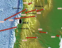
The 8.8 magnitude earthquake that struck Chile last month moved the city of Concepcion, the city closest to the quake’s epicenter, 10 feet to the west and shifted cities across the continent, according to an analysis of global positioning satellite (GPS) data. Santiago, Chile’s capital city, moved nearly a foot, and Buenos Aires, the Argentinean capital located on the other side of the continent, shifted about an inch, say researchers at Ohio State University, one of four universities and several agencies that have been studying the measurements since the Feb. 27 quake. Valparaiso, Chile, shifted 11 inches to the west and and Mendoza, Argentina, moved 3.5 inches in the same direction, said Michael Bevis, a professor of earth sciences at Ohio State who has measured crustal motion and deformation in the central and southern Andes since 1993. The massive quake occurred when the Nazca tectonic plate was subducted beneath the adjacent South American plate. Researchers compared GPS locations known prior to the quake with those recorded 10 days later. According to the U.S. Geological Survey, dozens of aftershocks have occurred in the days since the initial quake, some exceeding a magnitude of 6.0.
Earthquake Shifted Cities As Far As Ten Feet, Researchers Say
More From E360
-
INTERVIEW
In the Transition to Renewable Energy, China Is at a Crossroads
-
E360 Film Contest
In India, a Young Poacher Evolves into a Committed Conservationist
-
E360 Film Contest
The Amazon Rainforest Approaches a Point of No Return
-
Biodiversity
Shrinking Cod: How Humans Are Impacting the Evolution of Species
-
Cities
‘Sponge City’: Copenhagen Adapts to a Wetter Future
-
INTERVIEW
On Controlling Fire, New Lessons from a Deep Indigenous Past
-
Solutions
Paying the People: Liberia’s Novel Plan to Save Its Forests
-
OPINION
Forest Service Plan Threatens the Heart of an Alaskan Wilderness
-
INTERVIEW
Pakistan’s Solar Revolution Is Bringing Power to the People
-
Food & Agriculture
In Uganda, Deadly Landslides Force an Agricultural Reckoning
-
Energy
Why U.S. Geothermal May Advance, Despite Political Headwinds
-
Food & Agriculture
In War Zones, a Race to Save Key Seeds Needed to Feed the World