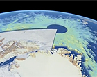
The European Space Agency’s (ESA) CryoSat satellite is now providing highly accurate data on the thickness and volume of Arctic Ocean ice. Using a high-resolution
synthetic aperture radar that sends down pulses of microwave energy, the satellite can measure the difference between the top of the ice and water in the cracks, or leads, that separate the floes. By measuring the height of the ice above water, which usually represents only one-eighth of total ice thickness, the satellite can provide data on ice thickness to within 10 to 20 centimeters, or 4 to 8 inches. The CryoSat satellite was launched in 2010, and since then scientists have been validating the measurements against other data from plane-based instruments and direct, on-ice measurements. “We now have a very powerful tool to monitor the changes taking place at the poles,” said Volker Liebig, the ESA’s director of Earth Observation.
European Satellite Provides Precise Data On Arctic Sea Ice Thickness
More From E360
-
Solutions
Beyond Lithium: New Battery Tech Starts to Break Through
-
INTERVIEW
What Do We Actually Know About the Microplastics Inside Us?
-
Energy
A Home Battery Revolution Is Reshaping the Power Grid
-
Energy
In East Africa, a Controversial Oil Project Is Poised for Production
-
Climate
A Missing Piece in Climate Models: Nature’s Own Emissions
-
INTERVIEW
An EPA Researcher Details the Agency’s Assault on Science
-
Oceans
Efforts to Save Kelp Forests from Ocean Warming Are Ramping Up
-
Biodiversity
Pollution Is Changing the Smells of Nature, With Risks for Wildlife
-
Oceans
Supertrawlers Are Taking Antarctic Krill That Whales Depend On
-
INTERVIEW
The U.S. Senator Who Won’t Shut Up about Climate Change
-
Energy
A First Among Major Nations, India Is Industrializing With Solar
-
A NOTE FROM THE EDITOR
After Two Decades, E360’s Founder and Editor Is Moving On