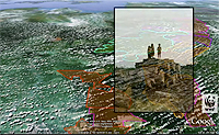
A new animation produced by the group WWF-Indonesia offers a tree-level tour of a biodiversity rich region of Sumatran rainforest targeted for destruction by logging companies. The animation, created using Google Earth, highlights proposed logging efforts in a region known as Bukit Tigapuluh, or “Thirty Hills,” a landscape that is home to endangered Sumatran tigers, elephants, rhinos, and orangutans, and represents one of the last large blocks of untouched forest in the area. While some parts of the region are protected as a national park, a large segment of lowland forest is located outside protected areas and is already concessioned for logging by major logging conglomerates. Google Earth has become an increasingly popular campaign tool for environmental organizations. Groups such as the Amazon Conservation Team and Amazon Watch have used it in efforts to halt illegal logging and the proposed construction of a dam on the Amazon River.
Google Earth Animation Highlights Region Targeted for Logging
More From E360
-
INTERVIEW
Pakistan’s Solar Revolution Is Bringing Power to the People
-
Food & Agriculture
In Uganda, Deadly Landslides Force an Agricultural Reckoning
-
Energy
Why U.S. Geothermal May Advance, Despite Political Headwinds
-
Food & Agriculture
In War Zones, a Race to Save Key Seeds Needed to Feed the World
-
Climate
Lightning Strikes the Arctic: What Will It Mean for the Far North?
-
RIVERS
A Win for Farmers and Tribes Brings New Hope to the Klamath
-
Solutions
Deconstructing Buildings: The Quest for New Life for Old Wood
-
NATURAL DEFENSES
How Restored Wetlands Can Protect Europe from Russian Invasion
-
Solutions
Birds vs. Wind Turbines: New Research Aims to Prevent Deaths
-
Biodiversity
Cambodian Forest Defenders at Risk for Exposing Illegal Logging
-
OPINION
The ‘Green’ Aviation Fuel That Would Increase Carbon Emissions
-
Solutions
Out of the Wild: How A.I. Is Transforming Conservation Science