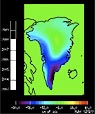
Using data from GPS sensors and satellites that measure gravity, a team of scientists from Denmark and the United States has shown that melting of Greenland’s massive ice sheet is now spreading to the northwest coast of the island. The rapid warming of Greenland — air temperatures there have jumped 4 degrees F in the last 20 years — led to the loss of an estimated 385 cubic miles of ice in southern Greenland from 2002 to 2009. Now, scientists have used a pair of gravity-measuring GRACE satellites and a network of GPS sensors to show that the loss of ice in northwest Greenland caused the earth’s crust to rise by 1.5 inches from 2005 to 2009. The uplift of the earth’s crust is directly related to the loss of ice pressing on Greenland’s bedrock, scientists say. The uplift indicates that some large glaciers in northwest Greenland are warming and sliding more rapidly to the sea, according to the study conducted by scientists at the Denmark Technical Institute’s National Space Institute and the University of Colorado at Boulder. “Our results show that the ice loss, which has been well documented over southern portions of Greenland, is now spreading up the northwest coast,” said Shfaqat Abbas Khan, lead author of the study that will appear in the journal Geophysical Research Letters.
Greenland Ice Sheet Loss Is Spreading to Northwest Coast, Study Says
More From E360
-
Climate
Heat Stress Is a Major Driver of India’s Kidney Disease Epidemic
-
Energy
It’s a ‘Golden Age’ for U.S. LNG Industry, But Climate Risks Loom
-
Climate
How Climate Risks Are Putting Home Insurance Out of Reach
-
INTERVIEW
Inside the Plastics Industry Playbook: Delay, Deny, and Distract
-
Biodiversity
Freeing Captive Bears from Armenia’s Backyards and Basements
-
Food & Agriculture
In Indonesia’s Rainforest, a Mega-Farm Project Is Plowing Ahead
-
FILM CONTEST WINNER
In the Yucatan, the High Cost of a Boom in Factory Hog Farms
-
INTERVIEW
In the Transition to Renewable Energy, China Is at a Crossroads
-
E360 Film Contest
In India, a Young Poacher Evolves into a Committed Conservationist
-
E360 Film Contest
The Amazon Rainforest Approaches a Point of No Return
-
Biodiversity
Shrinking Cod: How Humans Are Impacting the Evolution of Species
-
Cities
‘Sponge City’: Copenhagen Adapts to a Wetter Future