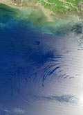
Scientists are using NASA satellites to track natural oil slicks seeping to the surface of the world’s oceans, providing better leads on potential sources of greenhouse gas emissions as the slicks break up and release carbon dioxide. Such natural seepage accounts for almost half of the oil that enters the earth’s oceans, according to a report in New Scientist. While typical satellite radar images enable scientists to monitor seepage spots every 8 to 16 days, new techniques of analyzing NASA’s MODIS images can detect a broader spectrum of wavelengths, including the visual range, allowing a scan of the surface of the earth daily. That is particularly significant since the sheen of an oil slick can disintegrate within two days. One research team used MODIS to monitor the northwestern Gulf of Mexico, and the image of a naturally occurring slick can be seen, at left. Scientists say monitoring areas of persistent seabed oil seepage provides an opportunity to study the unique seafloor ecosystems that have evolved near seepage vents, potentially leading to the development of new ways to clean up man-made oil spills.
NASA Satellite Technology Can Monitor Natural Oil Seepage
More From E360
-
INTERVIEW
Pakistan’s Solar Revolution Is Bringing Power to the People
-
Food & Agriculture
In Uganda, Deadly Landslides Force an Agricultural Reckoning
-
Energy
Why U.S. Geothermal May Advance, Despite Political Headwinds
-
Food & Agriculture
In War Zones, a Race to Save Key Seeds Needed to Feed the World
-
Climate
Lightning Strikes the Arctic: What Will It Mean for the Far North?
-
RIVERS
A Win for Farmers and Tribes Brings New Hope to the Klamath
-
Solutions
Deconstructing Buildings: The Quest for New Life for Old Wood
-
NATURAL DEFENSES
How Restored Wetlands Can Protect Europe from Russian Invasion
-
Solutions
Birds vs. Wind Turbines: New Research Aims to Prevent Deaths
-
Biodiversity
Cambodian Forest Defenders at Risk for Exposing Illegal Logging
-
OPINION
The ‘Green’ Aviation Fuel That Would Increase Carbon Emissions
-
Solutions
Out of the Wild: How A.I. Is Transforming Conservation Science