Two false-color thermal images taken by NASA satellites depict the rapid retreat of the Columbia Glacier in Alaska over the past 25 years. Since 1986, the
glacier’s end-point, or terminus, has retreated 12 miles up an inlet in Prince William Sound, and the glacier has lost about half its total thickness and volume. The top image, taken by a Landsat 5 satellite in 1986, shows two branches of the glacier joining together just north of Heather Island. By 2011, the terminus had retreated far up the inlet, and is identifiable in the bottom image. The blue in the water below the 2011 terminus is floating ice that has calved off the leading edge of the Columbia Glacier, which descends from a 10,000-foot ice field. By 2011, the two branches of the glacier had become separated. The turquoise in the images is snow, and it is more prevalent in 2011 because that image was taken in May, while the top image was shot in July.
Click to enlarge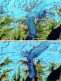
NASA
Alaska’s Columbia Glacier, 1986—2011