Earth Observatory
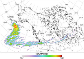
This graphic, from NASA’s Earth Observatory, shows
the path of high-altitude sulfur dioxide from the eruption of Okmok Volcano in Alaska’s Aleutian Islands. The eruption, which began on July 12, shot large clouds of gases and ash into the atmosphere, with a plume of SO
2 eventually climbing to 16 kilometers (10 miles). An instrument known as an Atmospheric Infrared Sounder (AIRS) on NASA’s Aqua satellite followed the sulfur dioxide plume from July 12-20. The red-orange color southeast of the Aleutians represents the highest concentrations of SO
2, which steadily diminished as prevailing winds carried the gas over the northern tier of the U.S. and into eastern Canada. Sulfur dioxide can pose health hazards near the earth’s surface, but at 16 kilometers the main effect of the gas occurs when it is converted into sulfate aerosol particles that reflect sunlight back into space. Large eruptions, such as that of Mount Pinatubo in 1991, can lead to cooler global temperatures for months or years. Okmok’s relatively small eruption is not expected to appreciably affect global climate.