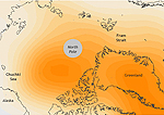
U.S. scientists say unusual air pressure patterns over the Arctic during the month of June in recent years have altered wind patterns in the region, funneling warmer air into the Arctic and contributing to record low Arctic
summer sea ice extent from 2007 to 2012. Writing in the journal Geophysical Research Letters, a team of researchers illustrated how the formation of two unusual high pressure areas over the North American Arctic and Greenland disrupted the normal westerly flow of winds, creating “blocking highs” that led to an unusually strong flow of warm southerly air. That sent more warm air into the central Arctic and Greenland, which may have been a factor in unusually dramatic summer thaws beginning in 2007. While it is unclear why these unusual patterns of high pressure have occurred in each of the last six Junes, NOAA researcher James Overland believes it may be related to declining snow cover in the Canadian Arctic in recent years. “We don’t know that part of the story yet,” he said.
View images
NOAA
Air pressure over the Arctic, 2007-2012.